Boppard
| Boppard | ||
|---|---|---|

Boppard
|
||
|
||
| Coordinates: 50°13′53″N 7°35′27″E / 50.23139°N 7.59083°ECoordinates: 50°13′53″N 7°35′27″E / 50.23139°N 7.59083°E | ||
| Country | Germany | |
| State | Rhineland-Palatinate | |
| District | Rhein-Hunsrück-Kreis | |
| Government | ||
| • Mayor | Walter Bersch (SPD) | |
| Area | ||
| • Total | 75.13 km2 (29.01 sq mi) | |
| Population (2015-12-31) | ||
| • Total | 15,404 | |
| • Density | 210/km2 (530/sq mi) | |
| Time zone | CET/CEST (UTC+1/+2) | |
| Postal codes | 56154 | |
| Dialling codes | 06741, 06742, 06745 | |
| Vehicle registration | SIM | |
| Website | www |
|
Boppard, formerly also spelled Boppart, is a town and municipality (since the 1976 inclusion of 9 neighbouring villages, Ortsbezirken) in the Rhein-Hunsrück-Kreis (district) in Rhineland-Palatinate, Germany, lying in the Rhine Gorge, a UNESCO World Heritage Site. The town is also a state-recognized tourism resort (Fremdenverkehrsort) and is a winegrowing centre.
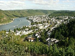
Boppard lies on the upper Middle Rhine, often known as the Rhine Gorge. This characteristic narrow form of valley arose from downward erosion of the Rhine’s riverbed. Since 2002, the Gorge has been a UNESCO World Heritage Site. A 17 km stretch of the Rhine forms the town’s eastern limit. Along this part of the river lie the outlying centres of Hirzenach and Bad Salzig, as well as the town’s main centre, also called Boppard.
Directly north of Boppard, the Rhine takes its greatest bend. This bow is called the Bopparder Hamm, although this name is more commonly applied to the winegrowing area found along it. The best known lookout point over this bow in the Rhine is the Vierseenblick, or "Four-Lake View". This vista gets its name from the way in which the Rhine can be seen from here, or rather the way in which it cannot be seen: hills block out most of the view of the river itself so that visitors can only see four apparently separate patches of water, rather like four lakes. These are all actually parts of the Rhine; there are no lakes to be seen. The Vierseenblick can be reached by chairlift.
Boppard’s town forest is the second biggest in Rhineland-Palatinate with an area of 43.6 km².
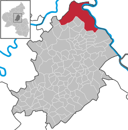
Since 1969, the town of Boppard has belonged to the Rhein-Hunsrück-Kreis, and is the district’s northernmost municipality. Boppard is a middle centre; the nearest upper centre is Koblenz, some 22 km away.
Since 1976, Boppard has consisted of ten Ortsbezirke, a special kind of municipal internal division found in some cities and towns in Rhineland-Palatinate (and also Hesse). Each Ortsbezirk has its own council, whose head bears the title Ortsvorsteher. Some of these Ortsbezirke even have their own Ortsteile, but these have no separate representation on any council. Boppard’s Ortsbezirke are as follows:
...
Wikipedia


