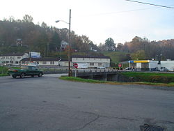
Boones Mill, Virginia
| Boones Mill, Virginia | |
|---|---|
| Town | |

Boones Mill, VA
|
|
| Motto: "Your Blue Ridge Gateway" | |
 Location in the state of Virginia |
|
| Coordinates: 37°6′56″N 79°57′14″W / 37.11556°N 79.95389°WCoordinates: 37°6′56″N 79°57′14″W / 37.11556°N 79.95389°W | |
| Country | United States |
| State | Virginia |
| County | Franklin |
| Incorporated | 1927 |
| Government | |
| • Mayor | Ben Flora |
| Area | |
| • Total | 0.7 sq mi (1.9 km2) |
| • Land | 0.7 sq mi (1.9 km2) |
| • Water | 0 sq mi (0 km2) |
| Elevation | 1,150 ft (350 m) |
| Population (2010) | |
| • Total | 239 |
| • Density | 326/sq mi (126.0/km2) |
| Time zone | EST (UTC-5) |
| • Summer (DST) | EDT (UTC-4) |
| ZIP code | 24065 |
| Area code(s) | 540 |
| FIPS code | 51-08584 |
| GNIS feature ID | 1492609 |
| Website | www |
Boones Mill is a town in Franklin County, Virginia, United States. The population was 239 at the 2010 census, down from 285 at the 2000 census. It is part of the Roanoke Metropolitan Statistical Area.
Boones Mill was incorporated in 1927. It was previously known as "Boone Mill" and "Boon Mill". The town is named after Jacob Boon who operated a mill in the town.
Bowman Farm, the Cahas Mountain Rural Historic District, Jubal A. Early House, and Piedmont Mill Historic District are listed on the National Register of Historic Places.
Boones Mill is located in northern Franklin County at 37°6′56″N 79°57′14″W / 37.11556°N 79.95389°W (37.115462, -79.953966), along U.S. Route 220 at the southern base of the Blue Ridge Mountains. US 220 leads north 14 miles (23 km) to Roanoke and south 10 miles (16 km) to Rocky Mount, the Franklin County seat.
According to the United States Census Bureau, the town has a total area of 0.73 square miles (1.9 km2), all of it land. The town is in the valley of Maggodee Creek, a southeast-flowing tributary of the Blackwater River, part of the Roanoke River watershed. Murray Knob, elevation 2,286 feet (697 m), rises 2 miles (3 km) to the north on the crest of the Blue Ridge, and the eastern end of Cahas Mountain, at 2,992 feet (912 m), is 2 miles to the west.
...
Wikipedia
