Roanoke, Virginia
| Roanoke, Virginia | |||
|---|---|---|---|
| Independent city | |||

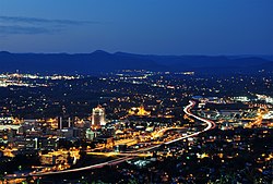
Downtown Roanoke from atop Mill Mountain.
|
|||
|
|||
| Nickname(s): The Star City of The South or Magic City | |||
| Location in Virginia | |||
| Coordinates: 37°16′15″N 79°56′30″W / 37.27083°N 79.94167°W | |||
| Country | United States | ||
| State | Virginia | ||
| County | None (Independent city) | ||
| Government | |||
| • Type | Council-Manager | ||
| • Mayor | Sherman Lea | ||
| Area | |||
| • Independent city | 43 sq mi (110 km2) | ||
| • Land | 43 sq mi (110 km2) | ||
| • Water | 0.3 sq mi (0.8 km2) | ||
| Elevation | 883–1,740 ft (269–530 m) | ||
| Population (2010) | |||
| • Independent city | 97,032 | ||
| • Density | 2,300/sq mi (870/km2) | ||
| • Metro | 312,331 | ||
| Time zone | Eastern (EST) (UTC-5) | ||
| • Summer (DST) | EDT (UTC-4) | ||
| ZIP Codes | 24001–24020, 24022–24038, 24040, 24042–24045, 24048, 24050, 24155, 24157 | ||
| Area code(s) | 540 | ||
| FIPS code | 51-68000 | ||
| GNIS feature ID | 1499971 | ||
| Website | www.roanokeva.gov | ||
Roanoke is an independent city in the southern U.S. state of Virginia. As of the 2010 census, the population was 97,032. It is located in the Roanoke Valley of the Roanoke Region of Virginia.
Roanoke is the largest municipality in Southwest Virginia, and is the principal municipality of the Roanoke Metropolitan Statistical Area (MSA), which had a 2010 population of 308,707. It is composed of the independent cities of Roanoke and Salem, and Botetourt, Craig, Franklin, and Roanoke counties. Bisected by the Roanoke River, Roanoke is the commercial and cultural hub of much of Southwest Virginia and portions of Southern West Virginia.
The town first called Big Lick was established in 1852 and chartered in 1874. It was named for a large outcropping of salt which drew the wildlife to the site near the Roanoke River. In 1882 it became the town of Roanoke, and in 1884 it was chartered as the independent city of Roanoke. The name Roanoke is said to have originated from an Algonquian word for shell "money". The name for the river was that used by the Algonquian speakers who lived 300 miles away where the river emptied into the sea near Roanoke Island. The native people who lived near where the city was founded did not speak Algonquian. They spoke Siouan languages, Tutelo and Catawban. There were also Cherokee speakers in that general area who fought with the Catawba people. The city grew frequently through annexation through the middle of the twentieth century. The last annexation was in 1976. The state legislature has since prohibited cities from annexing land from adjacent counties. Roanoke's location in the Blue Ridge Mountains, in the middle of the Roanoke Valley between Maryland and Tennessee, made it the transportation hub of western Virginia and contributed to its rapid growth.
...
Wikipedia


