Boone County, Iowa
| Boone County, Iowa | ||
|---|---|---|

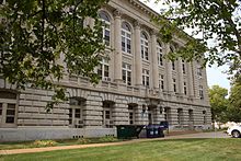
Boone County Courthouse
|
||
|
||
 Location in the U.S. state of Iowa |
||
 Iowa's location in the U.S. |
||
| Founded | 1846 | |
| Seat | Boone | |
| Largest city | Boone | |
| Area | ||
| • Total | 574 sq mi (1,487 km2) | |
| • Land | 572 sq mi (1,481 km2) | |
| • Water | 2.1 sq mi (5 km2), 0.4% | |
| Population | ||
| • (2010) | 26,306 | |
| • Density | 46/sq mi (18/km²) | |
| Congressional district | 4th | |
| Time zone | Central: UTC-6/-5 | |
| Website | www |
|
Boone County is a county in the U.S. state of Iowa. As of the 2010 census, the population was 26,306. Its county seat is Boone.
Boone County comprises the Boone, IA Micropolitan Statistical Area, which is included in the Des Moines-Ames-West Des Moines, IA Combined Statistical Area.
Boone County was established January 13, 1846, from free land. It was named after Captain Nathan Boone, son of Daniel Boone, an American pioneer, who had formed the Wilderness Trail and founded the town Boonesborough, Kentucky.
According to the U.S. Census Bureau, the county has a total area of 574 square miles (1,490 km2), of which 572 square miles (1,480 km2) is land and 2.1 square miles (5.4 km2) (0.4%) is water.
The 2010 census recorded a population of 26,306 in the county, with a population density of 46.07/sq mi (17.788/km2). There were 11,756 housing units, of which 10,728 were occupied.
As of the census of 2000, there were 26,224 people, 10,374 households, and 7,137 families residing in the county. The population density was 46 people per square mile (18/km²). There were 10,968 housing units at an average density of 19 per square mile (7/km²). The racial makeup of the county was 98.53% White, 0.36% Black or African American, 0.20% Native American, 0.22% Asian, 0.26% from other races, and 0.43% from two or more races. 0.83% of the population were Hispanic or Latino of any race.
...
Wikipedia

