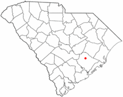
Bonneau, South Carolina
| Bonneau, South Carolina | |
|---|---|
| Town | |
| Motto: Where the living is easy... | |
 Location of Bonneau, South Carolina |
|
| Coordinates: 33°18′24″N 79°57′28″W / 33.30667°N 79.95778°WCoordinates: 33°18′24″N 79°57′28″W / 33.30667°N 79.95778°W | |
| Country | United States |
| State | South Carolina |
| County | Berkeley |
| Area | |
| • Total | 3.1 sq mi (7.9 km2) |
| • Land | 3.0 sq mi (7.8 km2) |
| • Water | 0.04 sq mi (0.1 km2) |
| Elevation | 59 ft (18 m) |
| Population (2010) | |
| • Total | 487 |
| • Density | 162/sq mi (62.4/km2) |
| Time zone | Eastern (EST) (UTC-5) |
| • Summer (DST) | EDT (UTC-4) |
| ZIP code | 29431 |
| Area code(s) | 843 |
| FIPS code | 45-07525 |
| GNIS feature ID | 1246941 |
Bonneau is a town in Berkeley County, South Carolina, United States. The population was 487 at the 2010 census. It is part of the Charleston–North Charleston–Summerville Metropolitan Statistical Area.
Bonneau is located in north-central Berkeley County on the east shore of Lake Moultrie at 33°18′24″N 79°57′28″W / 33.30667°N 79.95778°W (33.306720, -79.957836) The town is on the western edge of the Francis Marion National Forest. U.S. Route 52 passes through the town, leading south 41 miles (66 km) to Charleston and north 71 miles (114 km) to Florence.
According to the United States Census Bureau, the town has a total area of 3.1 square miles (7.9 km2), of which 3.0 square miles (7.8 km2) is land and 0.039 square miles (0.1 km2), or 1.74%, is water.
As of the census of 2000, there were 354 people, 156 households, and 99 families residing in the town. The population density was 125.6 people per square mile (48.5/km²). There were 176 housing units at an average density of 62.5 per square mile (24.1/km²). The racial makeup of the town was 76.55% White, 20.34% Black, 0.85% Native American, 1.13% from other races, and 1.13% from two or more races. Hispanic or Latino of any race were 0.85% of the population.
...
Wikipedia
