Bolshoy Lyakhovsky
| Native name: Большой Ляховский | |
|---|---|

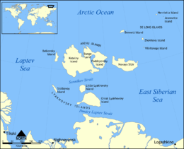
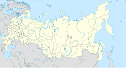
Map showing the location of Lyakhovsky Islands
|
|
|
Bolshoy Lyakhovsky Island (Russia)
|
|
| Geography | |
| Location | between the Laptev Sea and East Siberian Sea |
| Coordinates | 73°24′N 141°30′E / 73.4°N 141.5°ECoordinates: 73°24′N 141°30′E / 73.4°N 141.5°E |
| Archipelago | New Siberian Islands |
| Area | 4,600 km2 (1,800 sq mi) |
| Highest elevation | 270 m (890 ft) |
| Highest point | Emy Tas |
| Administration | |
|
Russia
|
|
Bolshoy Lyakhovsky Island (Russian: Большой Ляховский), or Great Lyakhovsky, is the largest of the Lyakhovsky Islands belonging to the New Siberian Islands archipelago between the Laptev Sea and the East Siberian Sea in northern Russia. It has an area of 4,600 km², and a maximum altitude of 270 m (Emy Tas).
The peninsula projecting towards the west of the island is the Kigilyakh Peninsula (Poluostrov Kigilyakh).
Off Bolshoy Lyakhovsky Island's southwestern cape lies a small islet called Ostrov Khopto-Terer.
The Lyakhovsky Islands are named in honour of Ivan Lyakhov, who explored them in 1773.
Bolshoy Lyakhovsky Island consists of highly folded and faulted Precambrian metamorphic rocks and turbidites; Mesozoic turbidites and igneous rocks; and Cenozoic sediments. Exposed in southeastern part of this island, the older Precambrian. Early Proterozoic, metamorphic rocks consist of schists and amphibolites. Small exposures of Late Proterozoic schistose, quartzose sandstones and phyllitic, sericite-quartz schist (turbidites) also occur in the southeastern part of Bolshoy Lyakhovsky Island. The bulk of this island consists of Late Jurassic to Early Cretaceous turbidites composed of interbedded fine-grained sandstones, thinly bedded siltstones, and argillites. The Precambrian and Late Jurassic to Early Cretaceous rocks are intruded by Late Cretaceous granites and granodiorites.
...
Wikipedia

