Bogotol
| Bogotol (in English) Боготол (Russian) |
|
|---|---|
| - Town - | |
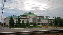
 Bogotol railway station |
|
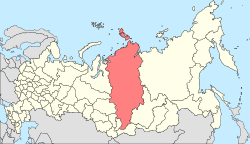
 Location of Krasnoyarsk Krai in Russia |
|
|
|
|
|
|
|
|
|
|
| Administrative status (as of April 2013) | |
| Country | Russia |
| Federal subject | Krasnoyarsk Krai |
| Administratively subordinated to | krai town of Bogotol |
| Administrative center of | krai town of Bogotol,Bogotolsky District |
| Municipal status (as of October 2008) | |
| Urban okrug | Bogotol Urban Okrug |
| Administrative center of | Bogotol Urban Okrug, Bogotolsky Municipal District |
| Statistics | |
| Population (2010 Census) | 21,051 inhabitants |
| Time zone | KRAT (UTC+07:00) |
| Founded | 1893 |
| Town status since | 1911 |
| Postal code(s) | 662060–662063 |
|
|
|
| on | |
Bogotol (Russian: Богото́л) is a town in Krasnoyarsk Krai, Russia, located 6 kilometers (3.7 mi) of the Chulym River and 252 kilometers (157 mi) west of Krasnoyarsk, the administrative center of the krai. Population: 21,051 (2010 Census);24,369 (2002 Census);27,752 (1989 Census).
It was founded in 1893 due to the construction of the Trans-Siberian Railway. The name derives from the Ket words bogotu (one of the Ket tribes in the area) and ul (river). Bogotol was granted town status in 1911.
Within the framework of administrative divisions, Bogotol serves as the administrative center of Bogotolsky District, even though it is not a part of it. As an administrative division, it is incorporated separately as the krai town of Bogotol—an administrative unit with the status equal to that of the districts. As a municipal division, the krai town of Bogotol is incorporated as Bogotol Urban Okrug.
...
Wikipedia


