Bogorodsky District, Nizhny Novgorod Oblast
| Bogorodsky District Богородский район (Russian) |
|
|---|---|
 Location of Bogorodsky District in Nizhny Novgorod Oblast |
|
| Coordinates: 56°05′59″N 43°30′26″E / 56.09972°N 43.50722°ECoordinates: 56°05′59″N 43°30′26″E / 56.09972°N 43.50722°E | |
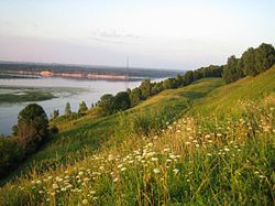
 View from the selo of Dudenevo on the Oka River and the Shukhov Tower |
|
| Location | |
| Country | Russia |
| Federal subject | Nizhny Novgorod Oblast |
| Administrative structure (as of January 2016) | |
| Administrative center | town of Bogorodsk |
| Administrative divisions: | |
| Towns of district significance | 1 |
| Selsoviets | 7 |
| Inhabited localities: | |
| Cities/towns | 1 |
| Rural localities | 143 |
| Municipal structure (as of August 2014) | |
| Municipally incorporated as | Bogorodsky Municipal District |
| Municipal divisions: | |
| Urban settlements | 1 |
| Rural settlements | 7 |
| Statistics | |
| Area (administrative district) (January 2016) | 1,459 km2 (563 sq mi) |
| Population (2010 Census) | 65,677 inhabitants |
| • Urban | 54.1% |
| • Rural | 45.9% |
| Density | 45.02/km2 (116.6/sq mi) |
| Time zone | MSK (UTC+03:00) |
| Established | 1929 |
| Official website | |
| on | |
Bogorodsky District (Russian: Богоро́дский райо́н) is an administrative district (raion), one of the forty in Nizhny Novgorod Oblast, Russia.Municipally, it is incorporated as Bogorodsky Municipal District. It is located in the west of the oblast. The area of the district is 1,459 square kilometers (563 sq mi). Its administrative center is the town of Bogorodsk. Population: 65,677 (2010 Census);30,864 (2002 Census);33,693 (1989 Census). The population of Bogorodsk accounts for 54.1% of the district's total population.
The district was established in 1929.
...
Wikipedia
