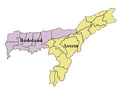
Bodoland
|
Bodoland बर'लेन्द |
|
|---|---|
| Aspirant state | |
 Map of Bodoland |
|
| Country | India |
| State | Assam |
| Proposed Capital | Kokrajhar |
| Languages | |
| • Official | Bodo |
| Time zone | IST (UTC+5:30) |
Bodoland (English pronunciation: /bədəʊˌlænd/, /'bəʊdəˌlænd/, (Bodo: बर'लेन्द}, (Hindi: बोडोलैंड) is a proposed state of India consisting of areas located in the extreme north on the north bank of the Brahmaputra river in the state of Assam, in north east region of India, by the foothills of Bhutan and Arunachal Pradesh. The region is predominantly inhabited by over one million indigenous Bodo people. Currently the map of Bodoland includes the Bodoland Territorial Area Districts (BTAD) administered by the Bodoland Territorial Council (BTC) and other parts covering over twenty-five thousands square kilometres. The territory came into existence under the BTC Accord in February 2003. The map of Bodoland overlaps with the districts of Kokrajhar, Baksa, Chirang and Udalguri in the state of Assam. At present, Kokrajhar serves as the capital of Bodoland Territorial Area Districts.
Bodoland (A land of Bodos) is the gateway to the North Eastern Region of India, where one of the main students organization, ABSU, along with other organizations have demanded that a separate state (within the Indian Union) be created by carving out some of eight districts of the current State of Assam, namely Kokrajhar, Dhubri, Bongaigaon, Barpeta, Nalbari, Kamrup, Darang and Sonitpur districts, while on the other hand it is also demanded as a sovereign state (Complete independence) by the separatist militant group NDFB. It is currently an autonomous Administrative unit constituted under the Sixth Schedule of the Constitution of India covering an area of 8,795 km2 (Provisional).
...
Wikipedia
