Bocognano
| Bocognano | |
|---|---|
| Commune | |

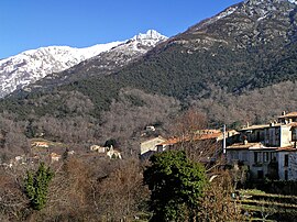
A view of part of the village
|
|
| Coordinates: 42°04′54″N 9°03′26″E / 42.0817°N 9.0572°ECoordinates: 42°04′54″N 9°03′26″E / 42.0817°N 9.0572°E | |
| Country | France |
| Region | Corsica |
| Department | Corse-du-Sud |
| Arrondissement | Ajaccio |
| Canton | Gravona-Prunelli |
| Intercommunality | Haute Vallée de la Gravona |
| Government | |
| • Mayor (2014–2020) | Achille Martinetti |
| Area1 | 71.12 km2 (27.46 sq mi) |
| Population (2008)2 | 482 |
| • Density | 6.8/km2 (18/sq mi) |
| Time zone | CET (UTC+1) |
| • Summer (DST) | CEST (UTC+2) |
| INSEE/Postal code | 2A040 /20136 |
| Elevation | 338–2,347 m (1,109–7,700 ft) (avg. 700 m or 2,300 ft) |
|
1 French Land Register data, which excludes lakes, ponds, glaciers > 1 km² (0.386 sq mi or 247 acres) and river estuaries. 2Population without double counting: residents of multiple communes (e.g., students and military personnel) only counted once. |
|
1 French Land Register data, which excludes lakes, ponds, glaciers > 1 km² (0.386 sq mi or 247 acres) and river estuaries.
Bocognano (in Corsican Bucugnà, pronounced [bu.ku.ɲa]) is a commune located in the department of Corse-du-Sud, on the island of Corsica, France. The village, situated at the south-western side of the climb to the Col de Vizzavona, belongs to the micro of Celavo which is historically the capital.
Halfway between Ajaccio and Corte, the village of Bocognano is renowned for its privileged position at the foot of Monte d'Oro, its chestnut woods and waterfall Le Voile de la Mariée. Bocognano, along with 9 other communes, belongs to the canton of Celavo-Mezzana. It is adherent to the Regional Natural Park of Corsica, in the Gravona territory. Its natural heritage, the purity of its sources, the quality of its reception and climate make it a popular summer destination near Ajaccio.
Bocognano is a mountain village located in the granite part of the island. It occupies an area surrounded by chains of high mountains of Monte d'Oro massif in the North, and the massif of Monte Renoso South, through which flows the Gravona river. It is the upper valley of the Gravona, the river taking its source on the slopes of Monte Renoso at 2110 m altitude.
The hydrographic network is dense. The river Gravona is fed by many streams which are only appointed on maps. Many springs rise in its territory and form natural fountains.
The territory has a tiered vegetation. Below the rocky peaks, clouds, appear odorant alders (bassu in Corsican), and beech woodlands can be found at the top of the valley. Lower altitudes are covered by forests, mainly composed of oaks and pines, and the chestnut wood located in an area between 600 and 800 meters. Chestnut trees planted along the road north of the village attracts many collectors and gatherers at the time of hatching bugs.
Three communal forests cover a large part of the city:
Bocognano is distant 38 km from the Ajaccio-Napoléon Bonaparte airport, and 42 km from the commercial port of Ajaccio.
...
Wikipedia


