Blyde River Canyon Nature Reserve
| Blyde River Canyon Nature Reserve | |
|---|---|

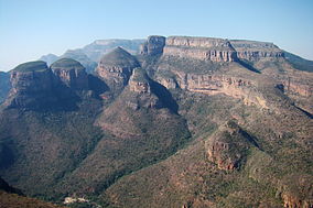
The Three Rondavels promontory of the Drakensberg escarpment
|
|
| Location | Northern Mpumalanga, South Africa |
| Nearest city | Graskop |
| Coordinates | 24°36′00″S 30°49′30″E / 24.60000°S 30.82500°ECoordinates: 24°36′00″S 30°49′30″E / 24.60000°S 30.82500°E |
| Area | 29,000 ha (290 km2) |
| Established | November 1965 |
| Governing body | Mpumalanga Tourism and Parks Agency (MTPA) |
| www |
|
Blyde River Canyon Nature Reserve (or Motlatse Canyon Provincial Nature Reserve) is situated in the Drakensberg escarpment region of eastern Mpumalanga, South Africa. The reserve protects the Blyde River Canyon, including sections of the Ohrigstad and Blyde Rivers and the geological formations around Bourke's Luck Potholes, where the Treur River tumbles into the Blyde below. Southwards of the canyon, the reserve follows the escarpment, to include the Devil's and God's Window, the latter a popular viewpoint to the lowveld at the reserve's southern extremity.
The Mogologolo (1,794 m), Mariepskop (1,944 m) and Hebronberg (1,767 m) massifs are partially included in the reserve. Elevation varies from 560 m to 1,944 m above sea level. Its resort areas are F.H. Odendaal and Swadeni, the latter only accessible from Limpopo province. The area of approximately 29,000 hectares (290 km2) is administered by the Mpumalanga Parks Board.
This geological feature and day visitors' attraction, is situated at the confluence of the Treur and Blyde Rivers, on the reserve's western boundary 24°40′28″S 30°48′39″E / 24.67444°S 30.81083°E. The reserve's nature conservation headquarters is located here, beside the village of Moremela, at the canyon's southern, or upper reaches.
...
Wikipedia

