Bloomfield Township, Bedford County, Pennsylvania
| Bloomfield Township, Bedford County, Pennsylvania |
|
|---|---|
| Township | |
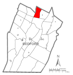
 Map of Bedford County, Pennsylvania highlighting Bloomfield Township |
|
 Map of Bedford County, Pennsylvania |
|
| Coordinates: 40°13′00″N 78°24′59″W / 40.21667°N 78.41639°WCoordinates: 40°13′00″N 78°24′59″W / 40.21667°N 78.41639°W | |
| Country | United States |
| State | Pennsylvania |
| County | Bedford |
| Settled | 1796 |
| Incorporated | 1876 |
| Area | |
| • Total | 19.40 sq mi (50.24 km2) |
| • Land | 19.39 sq mi (50.23 km2) |
| • Water | 0.01 sq mi (0.01 km2) |
| Population (2010) | |
| • Total | 1,016 |
| • Estimate (2016) | 992 |
| • Density | 51.16/sq mi (19.75/km2) |
| Time zone | Eastern (EST) (UTC-5) |
| • Summer (DST) | EDT (UTC-4) |
| Area code(s) | 814 |
| FIPS code | 42-009-07024 |
Bloomfield Township is a township in Bedford County, Pennsylvania, United States. The population was 1,016 at the 2010 census.
Bloomfield Township is located in northern Bedford County. It is bordered to the east by Woodbury Township, to the south by South Woodbury Township, at its southwest corner by King Township, and to the west by Kimmel Township. The north and part of the west borders of Bloomfield Township are the Bedford County line, with the Blair County townships of Greenfield and Taylor to the west and north, respectively. The western boundary of the township is formed by the ridgecrest of Dunning Mountain.
According to the United States Census Bureau, Bloomfield Township has a total area of 19.40 square miles (50.24 km2), of which 0.004 square miles (0.01 km2), or 0.03%, is water.
As of the census of 2000, there were 973 people, 335 households, and 278 families residing in the township. The population density was 50.0 people per square mile (19.3/km²). There were 356 housing units at an average density of 18.3/sq mi (7.1/km²). The racial makeup of the township was 98.97% White, 0.10% African American, 0.10% Native American, 0.10% Asian, 0.10% from other races, and 0.62% from two or more races. Hispanic or Latino of any race were 0.62% of the population.
...
Wikipedia
