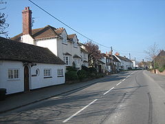
Blewbury
| Blewbury | |
|---|---|
 Blewbury |
|
| Blewbury shown within Oxfordshire | |
| Area | 17.17 km2 (6.63 sq mi) |
| Population | 1,581 (2011 Census) |
| • Density | 92/km2 (240/sq mi) |
| OS grid reference | SU5385 |
| Civil parish |
|
| District | |
| Shire county | |
| Region | |
| Country | England |
| Sovereign state | United Kingdom |
| Post town | Didcot |
| Postcode district | OX11 |
| Dialling code | 01235 |
| Police | Thames Valley |
| Fire | Oxfordshire |
| Ambulance | South Central |
| EU Parliament | South East England |
| UK Parliament | |
| Website | Blewbury Bulletin |
Blewbury is a village and civil parish at the foot of the Berkshire Downs section of the North Wessex Downs about 4 miles (6.4 km) south of Didcot, 14 miles (23 km) south of Oxford and 50 miles (80 km) west of London. It was part of Berkshire until the 1974 boundary changes transferred it to Oxfordshire. The 2011 Census recorded the parish's population as 1,581.
A number of springs rise at the foot of the escarpment of the downs. Some springs feed a small lake called the Watercress Beds, where watercress used to be cultivated. From here and elsewhere tributaries feed the Mill Brook which carries the water to the Thames at Wallingford. The A417 main road runs along below the escarpment above the springs and through the south of the village.
The southern part of the parish is chalk downland and includes a number of prehistoric sites. The Ridgeway is an ancient trackway that passes just south of the parish.
Half of the 360 feet (110 m) high Blewburton Hill is in the parish. It is topped by an Iron Age hill fort that may have been occupied from the 4th century BC to the 1st century BC. The parish's highest point is the 520 feet (160 m) Churn Hill, 1 1⁄2 miles (2.4 km) southwest of the village. On its northwestern side are two round barrows, the larger of which is Churn Knob. There are other round barrows further south, towards the boundaries with Compton and East Ilsley parishes.
During the Roman occupation a villa or temple was built near the Ridgeway on Lowbury Hill.
...
Wikipedia

