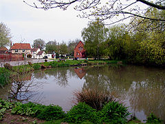
East Ilsley
| East Ilsley | |
|---|---|
 East Ilsley's village pond and small green with homes |
|
| East Ilsley shown within Berkshire | |
| Area | 15.02 km2 (5.80 sq mi) |
| Population | 1,571 (2011 census) |
| • Density | 105/km2 (270/sq mi) |
| OS grid reference | SU4981 |
| Civil parish | |
| Unitary authority | |
| Ceremonial county | |
| Region | |
| Country | England |
| Sovereign state | United Kingdom |
| Post town | Newbury |
| Postcode district | RG20 |
| Dialling code | 01635 |
| Police | Thames Valley |
| Fire | Royal Berkshire |
| Ambulance | South Central |
| EU Parliament | South East England |
| UK Parliament | |
| Website | Official website |
East Ilsley is a village and civil parish in the Berkshire or Lambourn Downs northern part of West Berkshire, north of Newbury centred immediately east of the A34 road dual carriageway which passes through the length of the village from north to south. It is in the ceremonial and historic county of Berkshire and has the vast majority of its buildings in a traditional clustered centre.
The village has a highest grade listed church that is mostly made from medieval stone, a minority of other buildings close by which are listed and pubs.
East Ilsley has an area to picnic by the pond, feeding the ducks, spend a few moments. Football is made available by local subscription on the recreation playground.
In 1620 East Ilsley was granted a charter to hold a sheep market in the village, however informally held from the reign of Henry II of England. This became the second largest sheep market, after Smithfield, London throughout the 19th century.
The parish was anciently called Hildersley, as in a medieval inscription in the church. West Ilsley was a hamlet in Ilsley. Ilsley has been attributed by antiquaries as a leading contender for the uncertain site of the Battle of Ashdown (Alfred the Great's victory against the Danes).Hilde-Laege a strong plausible root of Hildersley means "Battle place".
...
Wikipedia

