Blangy-sur-Bresle
| Blangy-sur-Bresle | ||
|---|---|---|

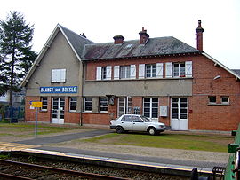
Blangy railway station
|
||
|
||
| Coordinates: 49°55′57″N 1°37′46″E / 49.9325°N 1.6294°ECoordinates: 49°55′57″N 1°37′46″E / 49.9325°N 1.6294°E | ||
| Country | France | |
| Region | Normandy | |
| Department | Seine-Maritime | |
| Arrondissement | Dieppe | |
| Canton | Eu | |
| Intercommunality | CC Aumale - Blangy-sur-Bresle | |
| Government | ||
| • Mayor (2008–2014) | Claude Vialaret | |
| Area1 | 17.45 km2 (6.74 sq mi) | |
| Population (2010)2 | 2,971 | |
| • Density | 170/km2 (440/sq mi) | |
| Time zone | CET (UTC+1) | |
| • Summer (DST) | CEST (UTC+2) | |
| INSEE/Postal code | 76101 /76340 | |
| Elevation | 42–216 m (138–709 ft) (avg. 49 m or 161 ft) |
|
|
1 French Land Register data, which excludes lakes, ponds, glaciers > 1 km² (0.386 sq mi or 247 acres) and river estuaries. 2Population without double counting: residents of multiple communes (e.g., students and military personnel) only counted once. |
||
1 French Land Register data, which excludes lakes, ponds, glaciers > 1 km² (0.386 sq mi or 247 acres) and river estuaries.
Blangy-sur-Bresle is a commune in the department of Seine-Maritime in the Normandy region of northern France.
Blangy is a small town situated in the valley of the River Bresle – which here forms the border between Normandy and Picardie – some 40 kilometres (25 mi) east of Dieppe in the Pays de Bray. Forestry, farming, and light industry are the main economic activities. The town lies on the D49 and the D928 roads close to junction 5 of the A29 motorway. There is an SNCF railway station from which TER services run to Beauvais and Le Tréport.
...
Wikipedia


