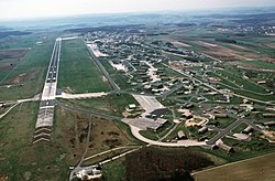
Bitburg Air Base
|
Bitburg Airport Flugplatz Bitburg |
|||||||||||
|---|---|---|---|---|---|---|---|---|---|---|---|
 |
|||||||||||
| Summary | |||||||||||
| Airport type | Public | ||||||||||
| Operator | Flugplatz Bitburg GmbH | ||||||||||
| Serves | Bitburg, Germany | ||||||||||
| Elevation AMSL | 1,223 ft / 373 m | ||||||||||
| Coordinates | 49°56′43″N 006°33′54″E / 49.94528°N 6.56500°ECoordinates: 49°56′43″N 006°33′54″E / 49.94528°N 6.56500°E | ||||||||||
| Map | |||||||||||
| Runways | |||||||||||
|
|||||||||||
|
Source: DAFIF
|
|||||||||||
Bitburg Airport (German: Flugplatz Bitburg) (IATA: BBJ, ICAO: EDRB) is a commercial airport serving Bitburg, a city in the Rhineland-Palatinate state of Germany. It is located 2 miles (3 km) southeast of Bitburg, 32 km (20 mile) north of Trier, and 217 km (135 miles) west of Wiesbaden.
From 1952 until 1994, Bitburg Air Base was a front-line NATO air base. It was the home of the United States Air Force's 36th Fighter Wing for over 40 years as part of the United States Air Forces in Europe (USAFE).
Under contract with the United States Air Force, the French Army began construction of what would become the base in Western Germany's Eifel Mountains in early 1951. Located in the French occupation zone, construction began on farm land that had been a Wehrmacht tank staging and supply area for the Battle of the Bulge in early 1944. The air base and its housing area occupied nearly 1,100 acres (445 ha), with a 8,200-foot (2,500 m) long runway (with 1,000-foot (300 m) overruns at each end, total length would be 10,200 ft).
In July 1952, the 53rd Fighter-Bomber Squadron from the 36th Wing moved from Fürstenfeldbruck Air Base a few miles west of Munich and arrived at the newly built base. Throughout the summer, elements of the 36th FBW moved into Bitburg, with the wing officially arriving in November 1952.
...
Wikipedia

