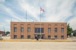
Bicknell, Indiana
| Bicknell, Indiana | |
|---|---|
| City | |
 |
|
 Location in the state of Indiana |
|
| Coordinates: 38°46′25″N 87°18′29″W / 38.77361°N 87.30806°WCoordinates: 38°46′25″N 87°18′29″W / 38.77361°N 87.30806°W | |
| Country | United States |
| State | Indiana |
| County | Knox |
| Government | |
| • Mayor | Thomas Estabrook(D) |
| Area | |
| • Total | 1.35 sq mi (3.50 km2) |
| • Land | 1.35 sq mi (3.50 km2) |
| • Water | 0 sq mi (0 km2) |
| Elevation | 528 ft (161 m) |
| Population (2010) | |
| • Total | 2,915 |
| • Estimate (2012) | 2,891 |
| • Density | 2,159.3/sq mi (833.7/km2) |
| Time zone | EST (UTC-5) |
| • Summer (DST) | EDT (UTC-4) |
| ZIP code | 47512 |
| Area code | 812, 930 |
| FIPS code | 18-05176 |
| GNIS ID | 431003 |
Bicknell is a city in Knox County, Indiana, United States. The population was 2,915 at the 2010 census.
Bicknell was laid out in 1869 by John Bicknell, and named for him.
Bicknell is located at 38°46′25″N 87°18′29″W / 38.77361°N 87.30806°W (38.773512, −87.307967). It is located in northeastern Knox County.
According to the 2010 census, Bicknell has a total area of 1.35 square miles (3.50 km2), all land.
The climate in this area is characterized by hot, humid summers and generally mild to cool winters. According to the Köppen Climate Classification system, Bicknell has a humid subtropical climate, abbreviated "Cfa" on climate maps.
As of the 2010 census, there were 2,915 people, 1,187 households, and 737 families residing in the city. The population density was 2,159.3 inhabitants per square mile (833.7/km2). There were 1,501 housing units at an average density of 1,111.9 per square mile (429.3/km2). The racial makeup of the city was 97.6% White, 0.5% African American, 0.2% Native American, 0.2% Asian, 0.4% from other races, and 1.0% from two or more races. Hispanic or Latino of any race were 1.9% of the population.
...
Wikipedia
