Bezirk Bialystok
|
Bezirk Bialystok Okręg białostocki |
|||||
| Bezirk of Nazi Germany | |||||
|
|||||
|
Flag |
|||||
| Bezirk Bialystok in 1942. | |||||
| Capital |
Białystok 53°08′N 23°09′E / 53.133°N 23.150°ECoordinates: 53°08′N 23°09′E / 53.133°N 23.150°E |
||||
| History | |||||
| • | Established | June 1941 | |||
| • | Disestablished | January 1945 | |||
| Political subdivisions | 8 kreisskomissariats | ||||
| Today part of |
|
||||
Flag
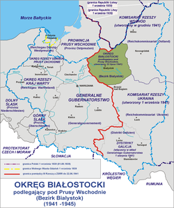
Bezirk Bialystok (German for District or Region of Białystok, also Belostok), was the new administrative unit of Nazi Germany that existed during the World War II occupation of Poland. It was located to the south-east of East Prussia, in the present-day northeastern Poland as well as in smaller sections of adjacent present-day Belarus and Lithuania.
The territory lay to the east of the Molotov-Ribbentrop line and was consequently occupied by the Soviet Union and incorporated into the Belarussian Soviet Socialist Republic. In the aftermath of the German attack on the Soviet Union in June 1941, this western portion of the then Soviet Belarus (which until 1939 belonged to the Polish state), was placed under German Civilian Administration (Zivilverwaltungsgebiet). As the Bezirk Bialystok, the area was under German rule from 1941 to 1944/1945, without ever formally being incorporated into the German Reich.
The district was established because of its perceived military importance as a bridgehead on the far bank of the Memel. Germany had desired to annex the area even during the First World War, based on the historical claim arising from the Third Partition of Poland, which had delegated Białystok to Prussia from 1795 to 1806 (see New East Prussia).
...
Wikipedia


