Beverly, New Jersey
| Beverly, New Jersey | |
|---|---|
| City | |
| City of Beverly | |
 Beverly highlighted in Burlington County. Inset map: Burlington County highlighted in the State of New Jersey. |
|
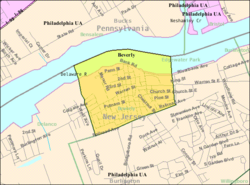
 Census Bureau map of Beverly, New Jersey |
|
| Coordinates: 40°03′53″N 74°55′19″W / 40.064811°N 74.921904°WCoordinates: 40°03′53″N 74°55′19″W / 40.064811°N 74.921904°W | |
| Country | |
| State |
|
| County | Burlington |
| Incorporated | March 5, 1850 |
| Named for | Beverley, England |
| Government | |
| • Type | City |
| • Body | Common Council |
| • Mayor | Randy H. Miller Sr. (D, term ends December 31, 2018) |
| • Administrator | Rich Wolbert |
| • Clerk | Donna Snyder |
| Area | |
| • Total | 0.785 sq mi (2.031 km2) |
| • Land | 0.555 sq mi (1.437 km2) |
| • Water | 0.230 sq mi (0.594 km2) 29.27% |
| Area rank | 523rd of 566 in state 38th of 40 in county |
| Elevation | 23 ft (7 m) |
| Population (2010 Census) | |
| • Total | 2,577 |
| • Estimate (2015) | 2,559 |
| • Rank | 469th of 566 in state 34th of 40 in county |
| • Density | 4,645.4/sq mi (1,793.6/km2) |
| • Density rank | 121st of 566 in state 3rd of 40 in county |
| Time zone | Eastern (EST) (UTC-5) |
| • Summer (DST) | Eastern (EDT) (UTC-4) |
| ZIP code | 08010 |
| Area code(s) | 609 |
| FIPS code | 3400505740 |
| GNIS feature ID | 0885160 |
| Website | www |
Beverly is a city in Burlington County, New Jersey, United States. As of the 2010 United States Census, the city's population was 2,577, reflecting a decline of 84 (-3.2%) from the 2,661 counted in the 2000 Census, which had in turn declined by 312 (-10.5%) from the 2,973 counted in the 1990 Census.
Beverly was originally incorporated as a borough on March 5, 1850, within Willingboro Township. Beverly was incorporated as a city by an act of the New Jersey Legislature on April 13, 1857, replacing Beverly borough, based on the results of a referendum held that day. Beverly Township, formed in 1859, co-existed alongside Beverly City and was renamed as Delanco Township in 1926. The borough was named for Beverley, England.
According to the United States Census Bureau, Beverly had a total area of 0.785 square miles (2.031 km2), including 0.555 square miles (1.437 km2) of land and 0.230 square miles (0.594 km2) of water (29.27%).
Beverly borders Edgewater Park Township, Delanco Township and Bensalem Township, Pennsylvania across the Delaware River.
The 2010 United States Census counted 2,577 people, 1,002 households, and 671.3 families residing in the city. The population density was 4,645.4 per square mile (1,793.6/km2). The city contained 1,086 housing units at an average density of 1,957.7 per square mile (755.9/km2). The racial makeup of the city was 61.66% (1,589) White, 29.88% (770) Black or African American, 0.16% (4) Native American, 0.78% (20) Asian, 0.00% (0) Pacific Islander, 2.68% (69) from other races, and 4.85% (125) from two or more races. Hispanics or Latinos of any race were 9.16% (236) of the population.
...
Wikipedia
