Beuningen
| Beuningen | ||
|---|---|---|
| Municipality | ||

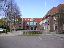
Beuningen town hall
|
||
|
||
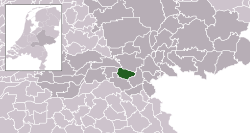
 Location in Gelderland |
||
| Coordinates: 51°52′N 5°47′E / 51.867°N 5.783°ECoordinates: 51°52′N 5°47′E / 51.867°N 5.783°E | ||
| Country | Netherlands | |
| Province | Gelderland | |
| Government | ||
| • Body | Municipal council | |
| • Mayor | Carol van Eert (PvdA) | |
| Area | ||
| • Total | 47.09 km2 (18.18 sq mi) | |
| • Land | 43.70 km2 (16.87 sq mi) | |
| • Water | 3.39 km2 (1.31 sq mi) | |
| Elevation | 9 m (30 ft) | |
| Population (February 2017) | ||
| • Total | 25,267 | |
| • Density | 578/km2 (1,500/sq mi) | |
| Demonym(s) | Beuninger | |
| Time zone | CET (UTC+1) | |
| • Summer (DST) | CEST (UTC+2) | |
| Postcode | 6550–6551, 6640–6645 | |
| Area code | 024, 0487 | |
| Website | www |
|
Beuningen (![]() pronunciation ) is a municipality and a town in the eastern Netherlands close to the city of Nijmegen. The municipality consists of the towns Beuningen, Ewijk, Winssen and Weurt. 1.5 kilometres (1 mi) to the north lies the river Waal
pronunciation ) is a municipality and a town in the eastern Netherlands close to the city of Nijmegen. The municipality consists of the towns Beuningen, Ewijk, Winssen and Weurt. 1.5 kilometres (1 mi) to the north lies the river Waal
Beuningen lies in the armpit of the A73 (Nijmegen-Venlo, on the south side) and A50 (Zwolle-Eindhoven, in the west) motorway interchange. In the north it borders the river Waal and Nijmegen in the east. Beuningen had a population of 25,267 in 2017. There is a restored windmill in the town, De Haag.
Dutch Topographic map of the municipality of Beuningen, June 2015.
...
Wikipedia


