Beskidy Mountains
| Beskids | |
|---|---|
| Beskidy (pl) Beskydy (cs/sk) |
|

Eastern Beskids in Zakarpattia Oblast, Ukraine
|
|
| Highest point | |
| Peak | Hoverla |
| Elevation | 2,060 m (6,760 ft) |
| Coordinates | 48°09′36″N 24°30′01″E / 48.16000°N 24.50028°E |
| Dimensions | |
| Length | 600 km (370 mi) |
| Width | 70 km (43 mi) |
| Geography | |
| Countries | Poland, Slovakia, Czech Republic and Ukraine |
| Regions | Silesia, Lesser Poland, Moravia and Carpathian Ruthenia |
| Range coordinates | 49°25′N 20°15′E / 49.42°N 20.25°ECoordinates: 49°25′N 20°15′E / 49.42°N 20.25°E |
| Parent range | Western and Eastern Carpathians |
| Borders on | Sudetes and Tatra Mountains |
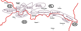
The Beskids or Beskid Mountains (Polish: Beskidy, Czech and Slovak: Beskydy, Rusyn: Бескиды (Beskidy), Ukrainian: Бескиди (Beskydy)) is a traditional name for a series of mountain ranges in the Carpathians, stretching from the Czech Republic in the west along the border of Poland with Slovakia up to Ukraine in the east.
The highest mountain in the Beskids is Hoverla, at 2,061 m metres (6,762 ft), located in the Ukrainian Chornohora range.
The origin of the name beskydy has not been conclusively established. A Thracian or Illyrian origin has been suggested, however, as yet, no theory has majority support among linguists. The word appears in numerous mountain names throughout the Carpathians and the adjacent Balkan regions, like in Albanian bjeshkë. The Slovak name Beskydy refers to the Polish Bieszczady Mountains, which is not a synonym for the entire Beskids but one single range, belonging to the Eastern Beskids. According to another linguistic theory, it may be related to Middle Low German beshêt, beskēt, meaning watershed.
Historically the Beschad Alpes Poloniae, first mentioned in a 1269 deed and called Poloniae Alpe Biesczade in the 17th century, denoted the mountain ranges which separated the Kingdom of Poland from Ruthenia and the Kingdom of Hungary.
...
Wikipedia

