Besiktas
|
Beşiktaş Beşiktaş Belediyesi |
|
|---|---|
| Municipality of Beşiktaş | |

Besiktas Square
|
|
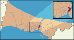
 Location of Beşiktaş in Istanbul |
|
| Location of Beşiktaş in Turkey | |
| Coordinates (Atatürk Statue, Beşiktaş Square): 41°4′10″N 29°1′40″E / 41.06944°N 29.02778°ECoordinates: 41°4′10″N 29°1′40″E / 41.06944°N 29.02778°E | |
| Country | Turkey |
| Province | Istanbul Province |
| Neighborhoods | |
| Government | |
| • Municipal president | Murat Hazinedar (CHP) |
| Area | |
| • District | 21.33 km2 (8.24 sq mi) |
| Population (2015) | |
| • District | 190,033 |
| • District density | 8,900/km2 (23,000/sq mi) |
| Website | www.besiktas.bel.tr |
Beşiktaş (pronounced [beˈʃictaʃ]) is a municipality () of Istanbul, Turkey, located on the European shore of the Bosphorus. It is bordered on the north by Sarıyer and Şişli, on the west by Kağıthane and Şişli, on the south by Beyoğlu, and on the east by the Bosphorus. Directly across the Bosphorus is the municipality of Üsküdar.
The Beşiktaş municipality includes a number of important sites along the European side of the Bosphorus, from Dolmabahçe Palace in the south to Bebek in the north. The municipality also includes many inland (and relatively expensive, upper-middle class) neighborhoods such as Levent and Etiler. Some of its other well-known neighborhoods include Yıldız, Kuruçeşme, Ortaköy, and Arnavutköy.
Beşiktaş' historic centre is Çarşı, which adjoins the small Abbasağa Park. The Barbaros Boulevard, which runs in south-north direction, is a major street serving as a feeder for the inner-city motorway ![]() on the Bosphorus Bridge, and terminating in Zincirlikuyu Junction, an important bus transport hub.
on the Bosphorus Bridge, and terminating in Zincirlikuyu Junction, an important bus transport hub.
...
Wikipedia

