Bernardsville, New Jersey
| Bernardsville, New Jersey | |
|---|---|
| Borough | |
| Borough of Bernardsville | |

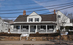
John Parker Tavern, then the Bernardsville Public Library, now vacant.
|
|
 Map of Bernardsville in Somerset County. Inset: Location of Somerset County in New Jersey. |
|
 Census Bureau map of Bernardsville, New Jersey. |
|
| Coordinates: 40°43′49″N 74°35′33″W / 40.730387°N 74.592571°WCoordinates: 40°43′49″N 74°35′33″W / 40.730387°N 74.592571°W | |
| Country | |
| State |
|
| County | Somerset |
| Incorporated | April 29, 1924 |
| Named for | Sir Francis Bernard, 1st Baronet |
| Government | |
| • Type | Borough |
| • Body | Borough Council |
| • Mayor | Kevin R. Sooy (R, term ends December 31, 2018) |
| • Administrator | Ralph A. Maresca Jr. |
| • Clerk | Sandra G. Jones |
| Area | |
| • Total | 12.980 sq mi (33.619 km2) |
| • Land | 12.905 sq mi (33.425 km2) |
| • Water | 0.075 sq mi (0.194 km2) 0.58% |
| Area rank | 184th of 566 in state 9th of 21 in county |
| Elevation | 682 ft (208 m) |
| Population (2010 Census) | |
| • Total | 7,707 |
| • Estimate (2015) | 7,801 |
| • Rank | 296th of 566 in state 13th of 21 in county |
| • Density | 597.2/sq mi (230.6/km2) |
| • Density rank | 428th of 566 in state 17th of 21 in county |
| Time zone | Eastern (EST) (UTC-5) |
| • Summer (DST) | Eastern (EDT) (UTC-4) |
| ZIP code | 07924 |
| Area code(s) | 908 |
| FIPS code | 3403505590 |
| GNIS feature ID | 0885159 |
| Website | www |
Bernardsville /ˈbɜːrnərdzvɪl/ is a borough in Somerset County, New Jersey, United States. In 2000, Bernardsville had the 10th-highest per capita income in the state. As of the 2010 United States Census, the borough's population was 7,707, reflecting an increase of 362 (+4.9%) from the 7,345 counted in the 2000 Census, which had in turn increased by 748 (+11.3%) from the 6,597 counted in the 1990 Census.
Bernardsville was incorporated as a borough by an act of the New Jersey Legislature on March 6, 1924, from portions of Bernards Township, based on the results of a referendum held on April 29, 1924. The borough was named for Sir Francis Bernard, 1st Baronet, who served as governor of the Province of New Jersey.
Bernardsville is often mispronounced as "Bern-ARDS-ville" as opposed to the correct parochial pronunciation "BERN-ards-ville".
In 2009, part of the borough was listed on the National Register of Historic Places as the Olcott Avenue Historic District.
Bernardsville was originally a section of Bernards Township known as Vealtown. In 1840, Vealtown became Bernardsville, named after Sir Francis Bernard, Colonial governor of New Jersey from 1758 to 1760. Located in the northernmost part of Somerset County, just 12 miles (19 km) south of Morristown, the borough includes some of the last vestiges of the Great Eastern Forest.
...
Wikipedia
