Bernalillo County, New Mexico
| Bernalillo County, New Mexico | ||
|---|---|---|

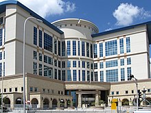
Bernalillo County Courthouse in Albuquerque
|
||
|
||
 Location in the U.S. state of New Mexico |
||
 New Mexico's location in the U.S. |
||
| Founded | 1852 | |
| Seat | Albuquerque | |
| Largest city | Albuquerque | |
| Area | ||
| • Total | 1,167 sq mi (3,023 km2) | |
| • Land | 1,161 sq mi (3,007 km2) | |
| • Water | 6.4 sq mi (17 km2), 0.5% | |
| Population (est.) | ||
| • (2015) | 676,685 | |
| • Density | 571/sq mi (220/km²) | |
| Congressional districts | 1st, 2nd, 3rd | |
| Time zone | Mountain: UTC-7/-6 | |
| Website | www |
|
Bernalillo County is the most populous county in the U.S. state of New Mexico. As of the 2010 census, the population was 662,564. The county seat is Albuquerque, which is the most populous city in New Mexico.
Bernalillo County is the central county of the Albuquerque, NM Metropolitan Statistical Area.
Bernalillo County was one of seven partidos established during Mexican rule; in 1852, within two years of the creation of the New Mexico Territory, Bernalillo became one of that territory's nine original counties. In 1876, it absorbed Santa Ana County.
In 1906, years after the Land Revision Act of 1891 provided for the setting aside of forest reserves, the parts of Bernalillo County currently known as Cibola National Forest were established as reserves.
USS LST-306, a World War II tank landing ship which participated in the Allied invasion of Italy, was renamed USS Bernalillo County in 1955. Sandia Mountain Wilderness was created in 1978 and the Petroglyph National Monument was established in June 1990.
According to the U.S. Census Bureau, the county has a total area of 1,167 square miles (3,020 km2), of which 1,161 square miles (3,010 km2) is land and 6.4 square miles (17 km2) (0.5%) is water. It is the third-smallest county in New Mexico by area.
...
Wikipedia

