Berleburg
| Bad Berleburg | ||
|---|---|---|
 |
||
|
||
| Coordinates: 51°02′59″N 08°24′00″E / 51.04972°N 8.40000°ECoordinates: 51°02′59″N 08°24′00″E / 51.04972°N 8.40000°E | ||
| Country | Germany | |
| State | North Rhine-Westphalia | |
| Admin. region | Arnsberg | |
| District | Siegen-Wittgenstein | |
| Government | ||
| • Mayor | Bernd Fuhrmann (Ind.) | |
| Area | ||
| • Total | 275.33 km2 (106.31 sq mi) | |
| Elevation | 350 - 789 m (−2,239 ft) | |
| Population (2015-12-31) | ||
| • Total | 19,774 | |
| • Density | 72/km2 (190/sq mi) | |
| Time zone | CET/CEST (UTC+1/+2) | |
| Postal codes | 57319 | |
| Dialling codes | 02751, 02750, 02755, 02758, 02759 | |
| Vehicle registration | SI, BLB | |
| Website | www.bad-berleburg.de | |
Bad Berleburg (![]() , earlier also Berleburg) is a town, in the district of Siegen-Wittgenstein, in North Rhine-Westphalia, Germany. It is one of Germany's largest towns by land area. It is located approximately 30 km northeast of Siegen and 35 km northwest of Marburg an der Lahn.
, earlier also Berleburg) is a town, in the district of Siegen-Wittgenstein, in North Rhine-Westphalia, Germany. It is one of Germany's largest towns by land area. It is located approximately 30 km northeast of Siegen and 35 km northwest of Marburg an der Lahn.
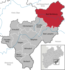
Bad Berleburg lies in the northeast of Siegen-Wittgenstein in the middle of the Rothaargebirge, a low mountain range. The western town limit is also the boundary with the neighbouring district of Olpe. The town is also bordered on the north by the Hochsauerland district. The town's eastern limit is likewise the boundary with the Bundesland of Hesse. The town of Bad Laasphe borders on Bad Berleburg in the south, and the community of Erndtebrück in the southwest.
The small river Odeborn flows through Berleburg and empties into the Eder further south.
Since 1975, the following villages have been part of Bad Berleburg:
(in each case at 31 December)
Archaeological finds confirm that the area covered by today's municipal area was settled as far back as the 7th century BC. On the castle hills at Aue, Dotzlar and Wemlighausen are traces of circular forts from this time. There is, however, no evidence of settlement in the area for the time that follows, up to the 8th century.
...
Wikipedia


