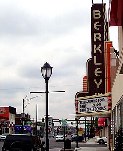
Berkley, Michigan
| Berkley | |
|---|---|
| City | |
| City of Berkley | |

Downtown Berkley
|
|
 Location in the state of Michigan |
|
| Coordinates: 42°30′11″N 83°11′01″W / 42.50306°N 83.18361°WCoordinates: 42°30′11″N 83°11′01″W / 42.50306°N 83.18361°W | |
| Country | United States |
| State | Michigan |
| County | Oakland |
| Incorporated | 1923 (village) |
| 1932 (city) | |
| Government | |
| • Mayor | Phil O'Dwyer |
| • Manager | Matthew Baumgarten |
| Area | |
| • Total | 2.62 sq mi (6.79 km2) |
| • Land | 2.62 sq mi (6.79 km2) |
| • Water | 0 sq mi (0 km2) |
| Elevation | 686 ft (209 m) |
| Population (2010) | |
| • Total | 14,970 |
| • Estimate (2012) | 15,123 |
| • Density | 5,713.7/sq mi (2,206.1/km2) |
| Time zone | EST (UTC-5) |
| • Summer (DST) | EDT (UTC-4) |
| ZIP code | 48072 |
| Area code(s) | 248 |
| FIPS code | 26-07660 |
| GNIS feature ID | 0621157 |
| Website | http://www.berkleymich.org |
Berkley is a suburb of Detroit located along the Woodward Corridor in southeastern Oakland County, Michigan. As of the 2010 census, the total population was 14,970.
The downtown area of Berkley stretches along 12 Mile Road between Greenfield Road and Coolidge Highway, and along Coolidge Highway between 12 Mile Road and 11 Mile Road. Berkley's municipal offices and public safety headquarters are located on 12 Mile Road just east of Coolidge Highway. The Berkley Parks and Recreation department is located at the community center on Catalpa Drive, just east of Anderson Middle School. This includes tennis courts, an ice arena, baseball fields, and a park.
Since the east border of Berkley is Woodward Avenue, the city is an active participant in the annual Woodward Dream Cruise, a popular classic car showcase in the Metro Detroit area. Berkley hosts a classic car parade along 12 Mile Road one day before the official date of the Dream Cruise.
According to the United States Census Bureau, the city has a total area of 2.62 square miles (6.79 km2), all land.
As of the census of 2010, there were 14,970 people, 6,594 households, and 3,896 families residing in the city. The population density was 5,713.7 inhabitants per square mile (2,206.1/km2). There were 6,933 housing units at an average density of 2,646.2 per square mile (1,021.7/km2). The racial makeup of the city was 93.3% White, 3.0% African American, 0.3% Native American, 1.3% Asian, 0.1% Pacific Islander, 0.3% from other races, and 1.8% from two or more races. Hispanic or Latino of any race were 1.8% of the population.
...
Wikipedia
