Benton Heights, Michigan
| Benton Heights, Michigan | |
|---|---|
| Census-designated place & Unincorporated community | |
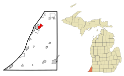
 Location of Benton Heights within Berrien County, Michigan |
|
| Location within the state of Michigan | |
| Coordinates: 42°7′52″N 86°24′26″W / 42.13111°N 86.40722°WCoordinates: 42°7′52″N 86°24′26″W / 42.13111°N 86.40722°W | |
| Country | United States |
| State | Michigan |
| County | Berrien |
| Township | Benton |
| Area | |
| • Total | 3.9 sq mi (10.0 km2) |
| • Land | 3.9 sq mi (10.0 km2) |
| • Water | 0.0 sq mi (0.0 km2) |
| Elevation | 633 ft (193 m) |
| Population (2010) | |
| • Total | 4,084 |
| • Density | 1,061/sq mi (409.8/km2) |
| Time zone | Eastern (EST) (UTC-5) |
| • Summer (DST) | EDT (UTC-4) |
| ZIP code | 49022 (Benton Harbor) |
| FIPS code | 26-07540 |
| GNIS feature ID | 0621145 |
Benton Heights is an unincorporated community in Berrien County in the U.S. state of Michigan. It is also a census-designated place (CDP) for statistical purposes without any legal status as an incorporated municipality. The population was 4,084 at the 2010 Census, down from 5,458 at the 2000 census. The community is a part of Benton Charter Township and is adjacent to the city of Benton Harbor.
According to the United States Census Bureau, the CDP has a total area of 3.9 square miles (10.0 km2), all land.
As of the census of 2000, there were 5,458 people, 1,944 households, and 1,310 families residing in the CDP. The population density was 1,419.8 per square mile (548.8/km²). There were 2,175 housing units at an average density of 565.8 per square mile (218.7/km²). The racial makeup of the CDP was 30.51% White, 65.63% Black or African American, 0.40% Native American, 0.13% Asian, 0.88% from other races, and 2.46% from two or more races. Hispanic or Latino of any race were 1.45% of the population.
...
Wikipedia

