Bennett, Colorado
| Town of Bennett, Colorado | |
|---|---|
| Statutory Town | |
 |
|
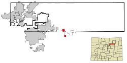
 Location in Adams County and the state of Colorado |
|
| Location in the contiguous United States | |
| Coordinates: 39°44′46″N 104°26′34″W / 39.745990°N 104.442841°WCoordinates: 39°44′46″N 104°26′34″W / 39.745990°N 104.442841°W | |
| Country |
|
| State |
|
| Counties |
Adams County Arapahoe County |
| Incorporated (town) | January 22, 1930 |
| Government | |
| • Type | Statutory Town |
| • Mayor | Sue Horn |
| Area | |
| • Total | 5.6 sq mi (14.4 km2) |
| • Land | 5.6 sq mi (14.4 km2) |
| • Water | 0 sq mi (0 km2) |
| Elevation | 5,485 ft (1,672 m) |
| Population (2010) | |
| • Total | 2,308 |
| • Density | 420/sq mi (160/km2) |
| Time zone | MST (UTC-7) |
| • Summer (DST) | MDT (UTC-6) |
| ZIP code | 80102 |
| Area code(s) | Both 303 and 720 |
| INCITS place code | 0806090 |
| GNIS feature ID | 0204738 |
| Website | www |
The Town of Bennett is a Statutory Town in Adams and Arapahoe counties in the U.S. state of Colorado. The town population was 2308 at the 2010 United States Census. Bennett is a part of the Denver-Aurora-Lakewood, CO Metropolitan Statistical Area.
Bennett was incorporated on January 22, 1930, and was named for Hiram Pitt Bennet, congressional delegate from the Territory of Colorado and Colorado Secretary of State.
Bennett is located at 39°45′13″N 104°25′43″W / 39.75361°N 104.42861°W (39.753604, -104.428580), at the intersection of State Highways 36 and 79, just north of Interstate 70.
According to the United States Census Bureau, the town has a total area of 5.6 square miles (14.4 km2), of which 0.0077 square miles (0.02 km2), or 0.10%, is water. The highest temperature ever recorded in Colorado occurred in Bennett on July 11, 1888, when it reached 118 °F (48 °C).
As of the census of 2000, there were 2,021 people, 715 households, and 539 families residing in the town. The population density was 652.3 people per square mile (251.7/km²). There were 732 housing units at an average density of 236.3 per square mile (91.2/km²). The racial makeup of the town was 94.56% White, 0.49% African American, 0.74% Native American, 0.30% Asian, 0.15% Pacific Islander, 1.63% from other races, and 2.13% from two or more races. Hispanic or Latino of any race were 4.45% of the population.
...
Wikipedia

