Ben Wyvis
| Ben Wyvis - Glas Leathad Mòr | |
|---|---|

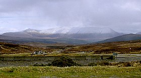
Ben Wyvis seen from near Loch Glascarnoch
|
|
| Highest point | |
| Elevation | 1,046 m (3,432 ft) |
| Prominence | c. 691 m |
| Parent peak | Beinn Dearg |
| Listing | Marilyn, Munro |
| Naming | |
| Translation | Hill of terror - big green slope (Gaelic) |
| Pronunciation | Scottish Gaelic: [peɲ ˈuəʃ ˈklˠ̪as̪ʎɛhət̪ ˈmoːɾ] |
| Geography | |
| Location | Easter Ross, Scotland |
| OS grid | NH463684 |
| Topo map | OS Landranger 20 |
| Listed summits of Ben Wyvis | ||||
| Name | Grid ref | Height | Status | |
|---|---|---|---|---|
| Glas Leathad Mòr | NH463684 | 1046 m | Munro, Marilyn | |
| Tom a' Chòinnich | NH463700 | 953 m | Munro Top | |
| An Cabar | NH450666 | 946 m | Munro Top | |
| Glas Leathad Beag | NH492706 | 928 m | Munro Top, HuMP | |
Ben Wyvis (from the Scottish Gaelic: Beinn Uais meaning "hill of terror") is a mountain located in Easter Ross, Ross and Cromarty, Highland, in northern Scotland, north-west of Dingwall. It forms an undulating ridge running roughly north-south for about 5 km, the highest summit of which is Glas Leathad Mòr. Geologically, the ridge is composed of Moine pelitic gneiss.
The summit ridge is carpeted with the woolly hair moss Racomitrium lanuginosum, rather than the heather or grass found on most other Scottish mountains, whilst the lower slopes support dwarf shrub heath and boglands. The heath and bogland is home to a variety of plants, including dwarf birch, cloudberry, dwarf cornel and alpine bearberry. The site is an important breeding ground for the Eurasian dotterel, and represents at least 2.4% of the breeding population in Great Britain. The site is designated as both a National Nature Reserve and a Special Protection Area.
It is usually climbed from the west, as that side is easy of access from the A835 road. The lower slopes are forested, and owned by the Forestry Commission. The summit ridge itself is a National Nature Reserve.
...
Wikipedia
