Belmont, Ohio
| Belmont, Ohio | |
|---|---|
| Village | |

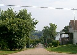
Streetside scenery
|
|
 Location of Belmont, Ohio |
|
 Location of Belmont in Belmont County |
|
| Coordinates: 40°1′39″N 81°2′27″W / 40.02750°N 81.04083°WCoordinates: 40°1′39″N 81°2′27″W / 40.02750°N 81.04083°W | |
| Country | United States |
| State | Ohio |
| County | Belmont |
| Township | Goshen |
| Government | |
| • Mayor | Stan Sobel |
| Area | |
| • Total | 0.27 sq mi (0.70 km2) |
| • Land | 0.27 sq mi (0.70 km2) |
| • Water | 0 sq mi (0 km2) |
| Elevation | 1,191 ft (363 m) |
| Population (2010) | |
| • Total | 453 |
| • Estimate (2012) | 447 |
| • Density | 1,677.8/sq mi (647.8/km2) |
| Time zone | Eastern (EST) (UTC-5) |
| • Summer (DST) | EDT (UTC-4) |
| ZIP code | 43718 |
| Area code(s) | 740 |
| FIPS code | 39-05312 |
| GNIS feature ID | 1064410 |
Belmont is a village in Belmont County, Ohio, United States. It is part of the Wheeling, West Virginia Metropolitan Statistical Area. The population was 453 at the 2010 census.
Belmont was originally known as Wrightstown, and under the latter name was laid out in 1808 by Joseph Wright. The name was switched to Belmont in anticipation of being the county seat of Belmont County.St. Clairsville, however, was given the honor of having Belmont County's center of government. The Baltimore and Ohio Railroad cut through the town until its dismantling in the 1980s.
Belmont is located at 40°1′39″N 81°2′27″W / 40.02750°N 81.04083°W (40.027560, -81.040807).
According to the United States Census Bureau, the village has a total area of 0.27 square miles (0.70 km2), all land.
Belmont is also located approximately one mile south of Barkcamp State Park. [1]
The Village is also part of the historic Drover's Trail that winds through the hills and valleys of Belmont County. [2]
As of the census of 2010, there were 453 people, 197 households, and 129 families residing in the village. The population density was 1,677.8 inhabitants per square mile (647.8/km2). There were 218 housing units at an average density of 807.4 per square mile (311.7/km2). The racial makeup of the village was 97.4% White, 0.4% African American, 1.3% Native American, and 0.9% from two or more races. Hispanic or Latino of any race were 0.2% of the population.
...
Wikipedia
