Belmont County, Ohio
| Belmont County, Ohio | ||
|---|---|---|

|
||
|
||
| Motto: Meliorem lapsa locavit (Latin, "He has planted one better than the one fallen") |
||
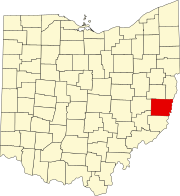
 Location in the U.S. state of Ohio |
||
 Ohio's location in the U.S. |
||
| Founded | March 1, 1815 | |
| Named for | "beautiful mountain" in French | |
| Seat | St. Clairsville | |
| Largest city | Martins Ferry | |
| Area | ||
| • Total | 541 sq mi (1,401 km2) | |
| • Land | 532 sq mi (1,378 km2) | |
| • Water | 9.1 sq mi (24 km2), 1.7% | |
| Population | ||
| • (2010) | 70,400 | |
| • Density | 132/sq mi (51/km²) | |
| Congressional district | 6th | |
| Time zone | Eastern: UTC-5/-4 | |
| Website | www |
|
Belmont County is a county located in the U.S. state of Ohio. As of the 2010 census, the population was 70,400. Its county seat is St. Clairsville. The county was created in 1801 and later organized in 1815. It takes its name from the French for "beautiful mountain".
Belmont County is part of the Wheeling, WV-OH Metropolitan Statistical Area. It is the only Belmont County nationwide.
Belmont County was formed from Jefferson and Washington counties, September 7, 1801.
In 1976, Belmont County became the first American county to elect a female sheriff, Katherine Crumbly.
In 1987, Michael A Massa, a county resident, created and dedicated the County's first Official Seal and Flag to the people of Belmont County (photo of county seal featured above the county map- see vignette at above right). The citizens of the county held an informal election to select the winning seal and flag, and the event was featured nationally on the Paul Harvey Show.
According to the U.S. Census Bureau, the county has a total area of 541 square miles (1,400 km2), of which 532 square miles (1,380 km2) is land and 9.1 square miles (24 km2) (1.7%) is water.
As of the census of 2000, there were 70,226 people, 28,309 households, and 19,250 families residing in the county. The population density was 131 people per square mile (50/km²). There were 31,236 housing units at an average density of 58 per square mile (22/km²). The racial makeup of the county was 94.98% White, 3.64% Black or African American, 0.14% Native American, 0.30% Asian, 0.02% Pacific Islander, 0.16% from other races, and 0.77% from two or more races. 0.39% of the population were Hispanic or Latino of any race. 20.2% were of German, 12.5% Irish, 12.0% American, 10.3% English, 10.2% Italian and 9.0% Polish ancestry according to Census 2000.
...
Wikipedia

