Bellville, Texas
| Bellville, Texas | |
|---|---|
| City | |

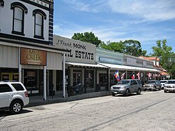
Stores along Holland Street on the courthouse square
|
|
| Motto: "A Texas Experience" | |
 Location of Bellville, Texas |
|
| Coordinates: 29°56′50″N 96°15′31″W / 29.94722°N 96.25861°WCoordinates: 29°56′50″N 96°15′31″W / 29.94722°N 96.25861°W | |
| Country | United States |
| State | Texas |
| County | Austin |
| Area | |
| • Total | 2.7 sq mi (6.9 km2) |
| • Land | 2.7 sq mi (6.9 km2) |
| • Water | 0.0 sq mi (0.0 km2) |
| Elevation | 292 ft (89 m) |
| Population (2010) | |
| • Total | 4,097 |
| • Density | 1,500/sq mi (590/km2) |
| Time zone | Central (CST) (UTC-6) |
| • Summer (DST) | CDT (UTC-5) |
| ZIP code | 77418 |
| Area code(s) | 979 |
| FIPS code | 48-07432 |
| GNIS feature ID | 1372492 |
| Website | www |
Bellville is a city in the U.S. state of Texas and the seat of Austin County. The city's population was 4,097 at the 2010 census. Bellville was named for Thomas B. Bell, one of Stephen F. Austin's earliest colonists, after he and his brother donated land for the new county seat established by voters in 1846. The original county seat was located in San Felipe. Bellville is located at the intersection of State Highway 36 and State Highway 159 as well as FM 529, FM 1456, and FM 2429. It is home to Trump Cafe, a restaurant named in honor of President Donald Trump.
Bellville is located in southern Austin County at 29°56′50″N 96°15′31″W / 29.94722°N 96.25861°W (29.947225, -96.258657).Sealy, along Interstate 10, is 10 miles (16 km) to the south, Hempstead is 15 miles (24 km) to the northeast, and Brenham is 18 miles (29 km) to the northwest. Downtown Houston is 64 miles (103 km) to the southeast via Sealy and Interstate 10.
According to the United States Census Bureau, Bellville has a total area of 2.7 square miles (6.9 km2), all of it land.
...
Wikipedia
