Belle Vernon, Pennsylvania
| Belle Vernon, Pennsylvania | |
| Borough | |
|
Belle Vernon, as seen from across the Monongahela River in a view showing the underside of the I-70 bridge looking ENE from Speers, PA
|
|
| Country | United States |
|---|---|
| State | Pennsylvania |
| County | Fayette |
| Coordinates | 40°7′37″N 79°52′6″W / 40.12694°N 79.86833°WCoordinates: 40°7′37″N 79°52′6″W / 40.12694°N 79.86833°W |
| Highest point | |
| - elevation | 1,080 ft (329 m) |
| Lowest point | |
| - elevation | 738 ft (225 m) |
| Area | 0.31 sq mi (1 km2) |
| - land | 0.25 sq mi (1 km2) |
| - water | 0.06 sq mi (0 km2) |
| Population | 1,093 (2010) |
| Density | 4,366.0/sq mi (1,686/km2) |
| Established | 1813 |
| Mayor | Gerald Jackson |
| Timezone | EST (UTC-4) |
| - summer (DST) | EDT (UTC-5) |
| Postal code | 15012 |
| Area code | 724 |
|
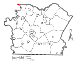
Location of Belle Vernon in Fayette County
|
|
Belle Vernon is a borough in Fayette County, Pennsylvania, Pennsylvania, United States. It is situated along the Monongahela River and is part of a greater community abutting two other counties, Westmoreland to the north and Washington across the river. As of the 2010 census Belle Vernon had a population of 1,093.
"Bellevernon", as it was originally spelled, was laid out in 1813 by Noah Speer in northwestern Fayette County. French for "beautiful green", this was the name chosen by both Noah Speer for his little community on the Monongahela River and later by his son Louis, who founded a town with nearly the same name just up the hill (North Belle Vernon). Directly across the river lies the borough of Speers, anchoring the far side of the landmark I-70 bridge as Belle Vernon does the east bridge abutments.
Belle Vernon is located at 40°7′37″N 79°52′6″W / 40.12694°N 79.86833°W (40.126936, -79.868285), nestled in the northwest corner of Fayette County, with abutting borders on Washington County, to the west across the river, and Westmoreland County to the north. The predominant terrains are riverine-influenced Appalachian Plateau foothills, with emphasis on the hills which break apart settlements into small pockets of buildable lands. Roads in the area follow the lines of least difficulty, hence knit otherwise isolate pockets of settlements into greater communities.
...
Wikipedia


