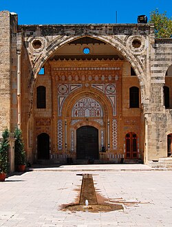
Beiteddine
|
Beit ed-Dine بيت الدين |
|
|---|---|
| Village | |

Beiteddine Palace
|
|
| Location within Lebanon | |
| Coordinates: 33°41′44″N 35°34′45″E / 33.69556°N 35.57917°ECoordinates: 33°41′44″N 35°34′45″E / 33.69556°N 35.57917°E | |
| Country |
|
| Governorate | Mount Lebanon |
| District | Chouf |
| Area | |
| • Total | 2.44 km2 (0.94 sq mi) |
| Elevation | 860 m (2,820 ft) |
| Time zone | EET (UTC+2) |
| • Summer (DST) | EEST (UTC+3) |
| Dialing code | +961 |
Beit ed-Dine (Arabic: بيت الدين), also known as Btaddine (Arabic: بتدين) is a small town and municipality in the Chouf District of the Mount Lebanon Governorate in Lebanon. It is the administrative capital of the Chouf District. The town is located 45 kilometers southeast of Beirut, and near the town of Deir el-Qamar from which it is separated by a steep valley. It had 1,613 registered voters in 2010 and its inhabitants are predominantly Christians from the Maronite, Melkite and Greek Orthodox denominations. Beit ed-Dine's total land area consists of 244 hectares and its average elevation is 860 meters above sea level. The town is well known for the Beiteddine Palace, which hosts the annual summer Beiteddine Festival.
Emir Bashir II of the Shihab dynasty, who later became the ruler of the Mount Lebanon Emirate, started building the palace in 1788 at the site of the Druze hermitage (hence the town's name, translating as "House of Faith"), indicating that the town was initially populated by Druze before Bashir lived in it. Bashir moved the headquarters of the emirate from Deir al-Qamar to Beit ed-Dine by 1811. He ruled from the palace he built, known as the Beiteddine Palace, which he supplied with water by building a lengthy canal connecting the palace to the Safa River.
...
Wikipedia

