Behchoko, Northwest Territories
|
Behchoko Behchokǫ̀ Rae-Edzo |
||
|---|---|---|
| Tłı̨chǫ Community Government | ||

Behchokǫ̀ on Great Slave Lake
|
||
|
||
| Coordinates: 62°48′09″N 116°02′47″W / 62.80250°N 116.04639°WCoordinates: 62°48′09″N 116°02′47″W / 62.80250°N 116.04639°W | ||
| Country | Canada | |
| Territory | Northwest Territories | |
| Region | North Slave Region | |
| Constituency | Monfwi | |
| Census division | Region 3 | |
| Tlicho Community Government | 4 August 2005 | |
| Government | ||
| • Chief | Clifford Daniels | |
| • Senior Administrative Officer | Violet Camsell-Blondin | |
| • MLA | Jackson Lafferty | |
| Area | ||
| • Land | 75.17 km2 (29.02 sq mi) | |
| Elevation | 179 m (587 ft) | |
| Population (2011) | ||
| • Total | 1,926 | |
| • Density | 25.6/km2 (66/sq mi) | |
| Time zone | Mountain (MST) (UTC−7) | |
| • Summer (DST) | MDT (UTC−6) | |
| Canadian Postal code | X0E 0Y0 | |
| Area code(s) | 867 | |
| Telephone exchange | 292, 371, 392 | |
| - Living cost | 127.5 | |
| - Food price index | 135.1 | |
| Sources: Department of Municipal and Community Affairs, Prince of Wales Northern Heritage Centre, Canada Flight Supplement ^A 2009 figure based on Edmonton = 100 ^B 2010 figure based on Yellowknife = 100 |
||
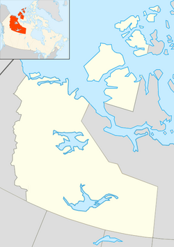
Behchokǫ̀ ([bɛ́ht͡ʃʰókʰõ̀] or [bɛ́ht͡sʰókʰõ̀] (from the Tłı̨chǫ meaning "Behcho's place"), officially the Tłı̨chǫ Community Government of Behchokǫ̀, is a community in the North Slave Region of the Northwest Territories, Canada. Behchokǫ̀ is located on the Yellowknife Highway (Great Slave Highway), on the northwest tip of Great Slave Lake, approximately 80 km (50 mi) northwest of Yellowknife.
The north arm of Great Slave Lake is the traditional territory of the Tłı̨chǫ (Dogrib), a northern Dene (formerly called Athapaskan) group. Explorer Samuel Hearne was the first European to encounter Dogrib-speaking people while crossing the barren lands north of Great Slave Lake in 1772. Later, in 1789, trader Alexander Mackenzie traveled by canoe very close to their territory while trading with the Yellowknives, another First Nations peoples, along the north arm of the big lake.
The first trading post in this region was at the entrance of Yellowknife Bay, established in 1789 by the North West Company, a post known as Old Fort Providence. It was established for the benefit of both the Yellowknives and Dogrib Dene but it was not a significant trading centre and closed in 1823. Dogrib Dene were then required to enter into trade with Hudson's Bay Company posts on the south side of Great Slave Lake at Fort Resolution at the mouth of the Slave River. Historically, the Dogrib and the Yellowknives Dene have quarreled. By the 1830s, Edzo, the Dogrib leader and Akaitcho, the Yellowknives leader, made peace. Afterwards, the Dogrib's returned to their traditional hunting grounds.
...
Wikipedia


