Baylor County, Texas
| Baylor County, Texas | |
|---|---|

The Baylor County Courthouse in Seymour
|
|
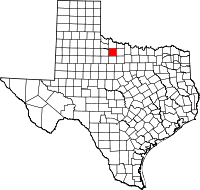
 Location in the U.S. state of Texas |
|
 Texas's location in the U.S. |
|
| Founded | 1879 |
| Named for | Henry Weidner Baylor |
| Seat | Seymour |
| Largest city | Seymour |
| Area | |
| • Total | 901 sq mi (2,334 km2) |
| • Land | 867 sq mi (2,246 km2) |
| • Water | 34 sq mi (88 km2), 3.7% |
| Population | |
| • (2010) | 3,726 |
| • Density | 4.3/sq mi (2/km²) |
| Congressional district | 13th |
| Time zone | Central: UTC-6/-5 |
| Website | www |
Baylor County is a county located in the U.S. state of Texas. As of the 2010 census, its population was 3,726. Its county seat is Seymour. The county was created in 1858 and later organized in 1879. It is named for Henry Weidner Baylor, a surgeon in the Texas Rangers during the Mexican-American War.
Baylor County is not to be confused with Baylor University, which is located approximately 230 miles southeast in McLennan County. Nor should its namesake be confused with Confederate Colonel George W. Baylor, who fought in Louisiana during the American Civil War.
Baylor County is represented in the Texas House of Representatives by the Republican James Frank, a businessman from Wichita Falls.
According to the U.S. Census Bureau, the county has a total area of 901 square miles (2,330 km2), of which 867 square miles (2,250 km2) is land and 34 square miles (88 km2) (3.7%) is water.
As of the census of 2000, there were 4,093 people, 1,791 households, and 1,156 families residing in the county. The population density was 5 people per square mile (2/km²). There were 2,820 housing units at an average density of 3 per square mile (1/km²). The racial makeup of the county was 90.96% White, 3.35% Black or African American, 0.59% Native American, 0.51% Asian, 0.12% Pacific Islander, 3.32% from other races, and 1.15% from two or more races; 9.33% were Hispanic or Latino of any race.
...
Wikipedia
