Batuan, Bohol
| Batuan | |
|---|---|
| Municipality | |

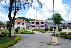
Poblacion Plaza
|
|
 Map of Bohol with Batuan highlighted |
|
| Location within the Philippines | |
| Coordinates: 9°48′N 124°08′E / 9.8°N 124.13°ECoordinates: 9°48′N 124°08′E / 9.8°N 124.13°E | |
| Country | Philippines |
| Region | Central Visayas (Region VII) |
| Province | Bohol |
| District | 3rd district of Bohol |
| Incorporated | 31 October 1903 |
| Barangay |
15 (see § Barangays)
|
| Government | |
| • Type | Sangguniang Bayan |
| • Mayor | Antonino Jumawid (LP) |
| • Vice mayor | Precious Joy Baguio |
| • Town Council |
Members
|
| • Representative | Arthur Yap |
| Area | |
| • Total | 79.08 km2 (30.53 sq mi) |
| • Land | 78.15 km2 (30.17 sq mi) |
| Population (2015 census) | |
| • Total | 12,767 |
| • Density | 160/km2 (420/sq mi) |
| • Voter (2016) | 8,359 |
| Time zone | PST (UTC+8) |
| ZIP code | 6318 |
| IDD : area code | +63 (0)38 |
| Income class | 5th class |
| PSGC | 071207000 |
Batuan is a 5th municipal income class municipality in the province of Bohol, Philippines. According to the 2015 census, it has a population of 12,767. In the 2016 electoral roll, it had 8,359 registered voters. Batuan is 51 km (32 miles) from Tagbilaran, and is located in the interior part of the island. It is accessible via the Tagbilaran—Loay—Carmen national road or the Tagbilaran—Balilihan—Batuan provincial road. It marches with Sagbayan to the north, with Bilar to the south, with Carmen and Valencia to the east, and with Catigbian and Balilihan to the west.
Batuan covers a total area of 7,908 hectares (19,540 acres) comprising fifteen barangays as per Municipal Comprehensive Development Plan for 1983–1992. However, a certification of the land area of Batuan, issued by ARED for operations, DENR Regional Office Region No. 7 Cebu City on 26 November 2001 at the instance of the LGU in connection with its Comprehensive Land Use Plan (CLUP) preparation work, showed a land area of only 4,878 hectares (12,050 acres), but that included only eleven barangays and excluded four – Quirino, Aloja, Behind the Clouds and Garcia.
Located within the province's tourist area, Batuan is the gateway to the Chocolate Hills, being only about 3 kilometres (1.9 mi) from the Chocolate Hills complex in Carmen.
This interior town used to be a barrio of Bilar during the Spanish regime and was called Lindugon. During the early years of American regime this barrio was made into a municipality by Act No. 370 of the Philippine Commission on 31 October 1903. Batuan became a separate municipality through the efforts of some local leaders, such as Manuel Decasa, Alejandro Barril, Victor Tiongson, among others, who were put behind bars for strongly advocating the movement to cede Batuan from its mother town Bilar, and its subsequent creation as a distinct and separate town. Notwithstanding, those leaders pursued their aspirations after release from prison. Municipality of Batuan was created, originally comprising only five barangays namely: Lindugon, Cambacay, Rosariohan, Janlud and Cantigdas; but today comprising fifteen.
...
Wikipedia

