Balilihan, Bohol
| Balilihan | ||
|---|---|---|
| Municipality | ||

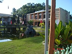
Balilihan municipal hall
|
||
|
||
 Map of Bohol with Balilihan highlighted |
||
| Location within the Philippines | ||
| Coordinates: 9°45′N 123°58′E / 9.75°N 123.97°ECoordinates: 9°45′N 123°58′E / 9.75°N 123.97°E | ||
| Country | Philippines | |
| Region | Central Visayas (Region VII) | |
| Province | Bohol | |
| District | 1st district of Bohol | |
| Founded | 29 September 1828 | |
| Barangay |
31 (see § Barangays)
|
|
| Government | ||
| • Type | Sangguniang Bayan | |
| • Mayor | Ma Pureza Chatto (LP) | |
| • Vice mayor | Adonis Roy Olalo | |
| • Town Council |
Members
|
|
| • Representative | Rene Relampagos | |
| Area | ||
| • Total | 127.27 km2 (49.14 sq mi) | |
| Elevation | 102 m (335 ft) | |
| Population (2015 census) | ||
| • Total | 17,903 | |
| • Density | 140/km2 (360/sq mi) | |
| • Voter (2016) | 11,556 | |
| Time zone | PST (UTC+8) | |
| ZIP code | 6342 | |
| IDD : area code | +63 (0)38 | |
| Income class | 4th class | |
| PSGC | 071206000 | |
| Website | balilihan |
|
Balilihan is a 4th municipal income class municipality in the province of Bohol, Philippines. Balilihan is located 22 kilometres (14 mi) northeast of Tagbilaran through Cortes (via CPG North Avenue), or 20 kilometres (12 mi) northeast through Corella (via J.A. Clarin Street). It has the fourth largest land area of the province, with 150 square kilometres (58 sq mi) of land. According to the 2015 census, it has a population of 17,903. In the 2016 electoral roll, it had 11,556 registered voters.
The place is a panorama of verdant hills, rugged mountains and green fields. It is said to have been so named because of the grass "balili" which grew in abundance.
Before the beginning of the 19th century, Balilihan was a barrio of Baclayon and an old settlement. When the Dagohoy revolt was suppressed by the Spaniards, the authorities established a garrison in Datag (one of its barrios) to discourage and stamp out further uprisings on the part of the natives. When Balilihan was separated from its mother town on 29 September 1828, the Spanish government formally established a settlement or pueblo in the sitio "Bay sa Iring" (named so for the network of caves where cats hide) which was about 2 kilometres (1.2 mi) from the Spanish garrison.
Later, due to the scarcity of water, the seat of government was transferred to its present site which is amply supplied with water from various springs. The elevated land also made a good viewing point to keep watch over all nearby towns. Thus the construction of a Spanish belfry similar to the watch towers of the shores atop the hill. This tower is made of adobe stones gathered from the rock deposits of Baclayon. It was erected in the year 1835. It was inaugurated in 1846 gobernadorcillo. In 1888, Friar Benito Grayoa, who at that time exercised control over local governments, ordered the transfer of the municipio to Cabad, a barrio 4 kilometres (2.5 mi) west of the poblacion. The padre's plan met vigorous opposition from the people and through the able leadership of Capitan Bartolome Racho, they filed the protest before the Spanish Military Governor Linares who disapproved the proposal causing Friar Grayoa's ire who then plotted for the consequent punishment of the captain by dragging him with the friar's horse through the streets causing his death in jail. Fearing reprisals from the clergy, some of the people migrated to Surigao, Leyte and Misamis. Not long afterwards, Friar Grayoa was transferred to Siquijor.
...
Wikipedia


