Battlefield, Glasgow
Battlefield
|
|
|---|---|
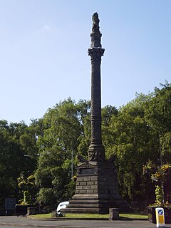
 Battlefield Monument, Glasgow |
|
| Battlefield shown within Glasgow | |
| OS grid reference | NS579614 |
| Council area | |
| Lieutenancy area |
|
| Country | Scotland |
| Sovereign state | United Kingdom |
| Post town | GLASGOW |
| Postcode district | G42 |
| Dialling code | 0141 |
| Police | Scottish |
| Fire | Scottish |
| Ambulance | Scottish |
| EU Parliament | Scotland |
| UK Parliament | |
| Scottish Parliament | |
Battlefield is a district in the Scottish city of Glasgow. It is situated south of the River Clyde. The area takes its name from the Battle of Langside of 1568 in which Mary, Queen of Scots' army was defeated by James VI. A highly decorative monument, designed by Alexander Skirving in 1887, now stands adjacent to Queen's Park commemorating the 320th anniversary of her defeat.
Housing consists mainly of three and four-storey Victorian and Edwardian tenements, although there are also numerous townhouses from the same era, and some modern properties.
Battlefield was formerly a centre of Glasgow's Jewish community, although most have now moved further south to Giffnock and Newton Mearns, or further afield to Manchester or Israel. The former synagogue had been converted to flats for social rent by the Arklet Housing Association.
The area includes one of Glasgow's main hospitals, the New Victoria Hospital (and the buildings of the (old) Victoria Infirmary), and further education institutions, Langside College. Another key local landmark, the Battlefield Rest building and clocktower, is now a restaurant.
Langside Library, at the junction of Sinclair Drive and Battlefield Road, is the final Carnegie library in Glasgow.
...
Wikipedia

