Barre des Écrins
| Barre des Écrins | |
|---|---|

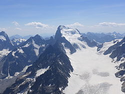
The Barre des Écrins (4,102 m) in Hautes Alpes, France and the Glacier Blanc
|
|
| Highest point | |
| Elevation | 4,102 m (13,458 ft) |
| Prominence | 2,045 m (6,709 ft) |
| Isolation | 107.3 kilometres (66.7 mi) |
| Listing | Ultra |
| Coordinates | 44°55′21″N 06°21′36″E / 44.92250°N 6.36000°ECoordinates: 44°55′21″N 06°21′36″E / 44.92250°N 6.36000°E |
| Geography | |
| Location | Hautes-Alpes, France |
| Parent range | Dauphiné Alps |
| Climbing | |
| First ascent | 25 June 1864 by A. W. Moore, Horace Walker and Edward Whymper with guides Michel Croz, Christian Almer Senior and Christian Almer Junior. |
| Easiest route | snow/rock climb |
The Barre des Écrins (4,102 m) is a mountain in the French Alps with a peak at 4102m altitude. It is the highest peak of the Massif des Écrins and the Dauphiné Alps and the most southerly alpine peak in Europe that is higher than 4,000 m. It is the only 4,000 m mountain in France that lies outside the Mont Blanc Massif. Before the annexation of Savoy in 1860 it was the highest mountain in France.
The Barre des Écrins is the highest peak in the Provence-Alpes-Côte d'Azur region including all of Occitania and the Southern Alps. It is located in the commune of Pelvoux and is situated near the Drainage divide between the Durance and the Vénéon. This divide passes 250 metres west of the summit, along the ridge that leads to the summit of the sub-peak Dôme des Écrins (4088 metres). The south face of the mountain is rocky while the north face is ice as it is the starting point of the Glacier Blanc.
The mountain is surrounded by four glaciers: to the north-west is the Bonne Pierre glacier, to the north-east the Glacier Blanc, to the south-west the Glacier du Vallon de la Pilatte, and finally in the south-east the Glacier Noir. It is separated from the Snow Dome of Écrins (4015 m) by the Lory Gap (3974 m) to the west, the Barre Noir (3751 m) by the Écrins Gap (3661 m) to the north-east and by Fifre (3699 m) via the Col des Avalanches (3499 m) to the south.
The mountain consists of migmatized gneiss, an acidic rock composed of quartz-feldspar. On the upper slopes there is an amphibolic face over the top of the migmatized gneiss forming the top. These formations overlap a large granite Pluton that forms the summit of Pelvoux.
...
Wikipedia

