Barnoldswick
Barnoldswick
|
|
|---|---|
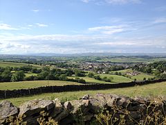
 A view from Weets Hill across Barnoldswick and Craven towards Ingleborough, Pen-y-ghent and Malham Cove in the Yorkshire Dales. |
|
| Barnoldswick shown within Lancashire | |
| Population | 11,005 (2011) |
| OS grid reference | SD875465 |
| Civil parish |
|
| District | |
| Shire county | |
| Region | |
| Country | England |
| Sovereign state | United Kingdom |
| Post town | BARNOLDSWICK |
| Postcode district | BB18 |
| Dialling code | 01282 |
| Police | Lancashire |
| Fire | Lancashire |
| Ambulance | North West |
| EU Parliament | North West England |
| UK Parliament | |
Barnoldswick (colloquially known as Barlick) is a town and civil parish in Lancashire, England. Near the county border with North Yorkshire, it is just outside the Yorkshire Dales National Park and the Forest of Bowland Area of Outstanding Natural Beauty. The town is built in the shadow of Weets Hill, and , a tributary of the River Ribble, runs through the town. It has a population of 11,005.
Barnoldswick and the surrounding areas of West Craven were part of the historic West Riding of Yorkshire between 876 (the earliest known written reference to the Ridings of York in the Anglo Saxon Chronicles) and 1974, when local government was reorganised; West Riding County Council and Barnoldswick Urban District Council were abolished and replaced in this area by the Borough of Pendle, a part of Lancashire.
Situated on the lower slopes of Weets Hill in the Pennines astride the natural watershed between the Ribble and Aire valleys, Barnoldswick is the highest town on the Leeds and Liverpool Canal, lying on the summit level of the canal between Barrowford Locks to the south west and Greenberfield Locks just north east of the town. It is approximately 30 miles (48 km) from the cities of Leeds, Manchester and Preston. Nearby towns include Skipton to the east, Clitheroe to the west, Burnley to the south and Keighley to the east southeast.
...
Wikipedia

