Barnesville, Minnesota
| Barnesville, Minnesota | |
|---|---|
| City | |

Barnesville water tower
|
|
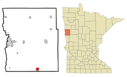
 Location of Barnesville within Clay County and state of Minnesota |
|
| Coordinates: 46°39′7″N 96°25′0″W / 46.65194°N 96.41667°W | |
| Country | United States |
| State | Minnesota |
| County | Clay |
| Area | |
| • Total | 2.22 sq mi (5.75 km2) |
| • Land | 2.20 sq mi (5.70 km2) |
| • Water | 0.02 sq mi (0.05 km2) |
| Elevation | 1,024 ft (312 m) |
| Population (2010) | |
| • Total | 2,563 |
| • Estimate (2013) | 2,570 |
| • Density | 1,165.0/sq mi (449.8/km2) |
| Time zone | Central (CST) (UTC-6) |
| • Summer (DST) | CDT (UTC-5) |
| ZIP code | 56514 |
| Area code(s) | 218 |
| FIPS code | 27-03574 |
| GNIS feature ID | 0639637 |
| Website | barnesvillemn.com |
Barnesville is a city in Clay County, Minnesota, United States. The population was 2,563 at the 2010 census.Barnesville Potato Days is held there annually in August.
Interstate 94 and Minnesota State Highways 9, 52, and 34 are four of the main routes in the city.
Barnesville was founded in 1874 by George S. Barnes, and named for him. A post office called Barnesville has been in operation since 1877. Barnesville was incorporated as a city in 1889.
According to the United States Census Bureau, the city has a total area of 2.22 square miles (5.75 km2), of which 2.20 square miles (5.70 km2) is land and 0.02 square miles (0.05 km2) is water.
As of the census of 2010, there were 2,563 people, 1,013 households, and 696 families residing in the city. The population density was 1,165.0 inhabitants per square mile (449.8/km2). There were 1,095 housing units at an average density of 497.7 per square mile (192.2/km2). The racial makeup of the city was 98.3% White, 0.2% African American, 0.2% Native American, 0.2% Asian, 0.1% Pacific Islander, 0.2% from other races, and 0.8% from two or more races. Hispanic or Latino of any race were 0.7% of the population.
...
Wikipedia
