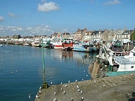
Barfleur
| Barfleur | ||
|---|---|---|
 |
||
|
||
| Coordinates: 49°40′16″N 1°15′48″W / 49.6711°N 1.2633°WCoordinates: 49°40′16″N 1°15′48″W / 49.6711°N 1.2633°W | ||
| Country | France | |
| Region | Normandy | |
| Department | Manche | |
| Arrondissement | Cherbourg | |
| Canton | Quettehou | |
| Intercommunality | Val de Saire | |
| Government | ||
| • Mayor (2008–2014) | Jean Deville | |
| Area1 | 0.6 km2 (0.2 sq mi) | |
| Population (2009)2 | 648 | |
| • Density | 1,100/km2 (2,800/sq mi) | |
| Time zone | CET (UTC+1) | |
| • Summer (DST) | CEST (UTC+2) | |
| INSEE/Postal code | 50030 / 50760 | |
|
1 French Land Register data, which excludes lakes, ponds, glaciers > 1 km² (0.386 sq mi or 247 acres) and river estuaries. 2Population without double counting: residents of multiple communes (e.g., students and military personnel) only counted once. |
||
1 French Land Register data, which excludes lakes, ponds, glaciers > 1 km² (0.386 sq mi or 247 acres) and river estuaries.
Barfleur is a commune in the Manche department in the Basse-Normandie region in northwestern France. It is twinned with Lyme Regis in the United Kingdom.
In the Middle Ages Barfleur was one of the chief ports of embarkation for England.
type "rébus"= bar=seabass + Fleur=flower (but the name Barfleur is actually of scandinavian origin : Barbefloth, Barba's river).
About 2 miles (3.2 km) to the north is Cape Barfleur, with a lighthouse 233 ft (71 m) high.
A Brittany Ferries vessel is named after the village and operates from nearby Cherbourg-Octeville to Poole in the United Kingdom.
...
Wikipedia


