Baraundha
| Baraundha State Pathar Kachhar बरौंधा रियासत |
|||||
| Princely State of British India | |||||
|
|||||
|
Coat of arms |
|||||
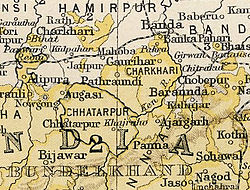
| Baraundha State in the Imperial Gazetteer of India | |||||
| History | |||||
| • | Established | 1549 | |||
| • | Independence of India | 1950 | |||
| Area | |||||
| • | 1892 | 565 km2(218 sq mi) | |||
| Population | |||||
| • | 1892 | 17,283 | |||
| Density | 30.6 /km2 (79.2 /sq mi) | ||||
| Princely States of India A-J | |||||
Coat of arms
Baraundha (also known as Pathar Kachhar) was a princely state of colonial India, located in modern Satna district of Madhya Pradesh. Although historically far larger, at the time of Indian independence in 1947, it was a petty Sanad state of about 565 km2.
The ruling family were members of the Raghuvansi line of Rajputs.
Coordinates: 25°03′N 80°38′E / 25.050°N 80.633°E
...
Wikipedia


