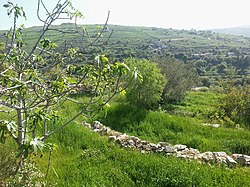
Baraachit
|
Baraachit برعشيت |
|
|---|---|
| City | |

Pastoral view of Baraachit
|
|
| Location within Lebanon | |
| Coordinates: 33°10′34″N 35°26′36″E / 33.17611°N 35.44333°ECoordinates: 33°10′34″N 35°26′36″E / 33.17611°N 35.44333°E | |
| Grid position | 191/286 PAL |
| Country |
|
| Governorate | Nabatieh Governorate |
| District | Bint Jbeil District |
| Elevation | 710 m (2,330 ft) |
| Time zone | EET (UTC+2) |
| • Summer (DST) | EEST (UTC+3) |
| Dialing code | +961 (07) |
Baraachit (Arabic: برعشيت ), also spelt Brashit, is a rural town located in the Nabatiye Governorate, in the Bint Jbeil District of southern Lebanon, ca. 3.5 kilometres (2.2 mi) southeast of Tibnine and about 80 kilometres (50 mi) from Beirut. The village sits on an elevation of 710 metres (2,330 ft) above sea level. The town has a mixed population of Shi'a and Christians.
The village once marked the northernmost extent of Jewish settlement upon their return from Babylonia in the 4th century BCE, and is mentioned in the 3rd century Mosaic of Rehob. By 64 BCE, the region had come under the control of the Roman empire. The area was also known since ancient times as Jabal 'Amilah, and later as Jabal 'Amil (Jabal Amel), an area that shoulders the Galilee and overlooks Palestine, with a predominant Shi'ite population.
In 1596, the village ‘’Bra’sit’’ was named in the Ottoman nahiya (subdistrict) of Tibnin under the liwa' (district) of Safad, with a population of 45 households and 7 bachelors, all Muslim. The villagers paid taxes on agricultural products, such as wheat, barley, olive trees, fruit trees, goats and beehives, in addition to "occasional revenues" and a fixed sum; a total of 13,370 akçe.
In 1875, Victor Guérin visited, and found here “a cistern partly cut in the rock, and partly constructed, seems ancient.” He found 400 Metawileh and 60 Greek Orthodox.
...
Wikipedia

