Bapatla mandal
|
Bapatla mandal బాపట్ల మండలం |
|
|---|---|
| Mandal | |

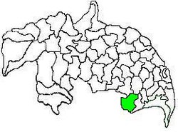
Mandal map of Guntur district showing
Bapatla mandal (in green) |
|
| Location in Andhra Pradesh, India | |
| Coordinates: 15°53′20″N 80°28′12″E / 15.88889°N 80.47000°ECoordinates: 15°53′20″N 80°28′12″E / 15.88889°N 80.47000°E | |
| Country | India |
| State | Andhra Pradesh |
| District | Guntur |
| Headquarters | Bapatla |
| Government | |
| • Body | Mandal Parishad |
| • Tehsildar | T.Valliah |
| Area | |
| • Total | 233.91 km2 (90.31 sq mi) |
| Population (2011) | |
| • Total | 143,825 |
| • Density | 610/km2 (1,600/sq mi) |
| Languages | |
| • Official | Telugu |
| Time zone | IST (UTC+5:30) |
Bapatla mandal is one of the 57 mandals in Guntur district of the state of Andhra Pradesh, India. It is under the administration of Tenali revenue division and the headquarters are located at Bapatla town. The mandal is bounded by Kakumanu, Ponnur, Karlapalem mandals of Guntur district. It also shares borders with Prakasam district and a portion of it lies on the coast of Bay of Bengal.
As of 2011[update]census, the mandal had a population of 143,825. The total population constitute, 70,847 males and 72,978 females —a sex ratio of 1030 females per 1000 males. 13,371 children are in the age group of 0–6 years, of which 6,856 are boys and 6,515 are girls. The average literacy rate stands at 71.79% with 93,653 literates.
As of 2011[update]census, the mandal has 21 settlements. It includes 20 villages and 1 town of Bapatla.
The settlements in the mandal are listed below:
Note: M-Municipality
The mandal is under the control of a tahsildar and the present tahsildar is T.Valliah. Bapatla mandal is one of the 3 mandals under Bapatla (Assembly constituency), which in turn represents Bapatla (SC) (Lok Sabha constituency) of Andhra Pradesh.
...
Wikipedia

