Bangerten
| Bangerten | ||
|---|---|---|
| Former municipality of Switzerland | ||

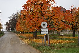
Entrance to Bangerten village
|
||
|
||
| Coordinates: 47°3′N 7°27′E / 47.050°N 7.450°ECoordinates: 47°3′N 7°27′E / 47.050°N 7.450°E | ||
| Country | Switzerland | |
| Canton | Bern | |
| District | Seeland | |
| Area | ||
| • Total | 2.2 km2 (0.8 sq mi) | |
| Elevation | 586 m (1,923 ft) | |
| Population (Dec 2014) | ||
| • Total | 151 | |
| • Density | 69/km2 (180/sq mi) | |
| Postal code | 3256 | |
| SFOS number | 0532 | |
| Surrounded by | Iffwil, Rapperswil, Scheunen, Zuzwil | |
| Website | SFSO statistics |
|
Bangerten is a former municipality in the Seeland administrative district in the canton of Bern in Switzerland. On 1 January 2016 it was absorbed into Rapperswil.
Bangerten is first mentioned in 1263 as Bongarthen. Roman coins have been found in Bangerten. In the 13th and 14th Centuries the Order of St. John in Münchenbuchsee bought out most of the earlier land owners, including the Burgdorf Family von Steffisburg. Following the Secularization of the monasteries (1528), Bangerten became part of the Landvogtei of Münchenbuchsee.
The municipality has remained generally agrarian. In 1990, 24 of the 42 workers in the village worked in agriculture. Due to agreements with neighboring municipalities, the small municipality has been able to function with limited local infrastructure. Bangerten shares the vital records and welfare office with Etzelkofen, a primary school with Scheunen and a secondary school with Rapperswil.
Bangerten had an area of 2.19 km2 (0.85 sq mi). Of this area, 1.36 km2 (0.53 sq mi) or 62.1% is used for agricultural purposes, while 0.7 km2 (0.27 sq mi) or 32.0% is forested. Of the rest of the land, 0.14 km2 (35 acres) or 6.4% is settled (buildings or roads).
Of the built up area, housing and buildings made up 3.2% and transportation infrastructure made up 3.2%. Out of the forested land, all of the forested land area is covered with heavy forests. Of the agricultural land, 49.8% is used for growing crops and 8.2% is pastures, while 4.1% is used for orchards or vine crops.
...
Wikipedia


