Banbridge
| Banbridge | |
|---|---|
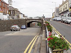
 'The Cut' in Banbridge |
|
| Banbridge shown within County Down | |
| Population | 16,653 (2011 Census) |
| District | |
| County | |
| Country | Northern Ireland |
| Sovereign state | United Kingdom |
| Post town | BANBRIDGE |
| Postcode district | BT32 |
| Dialling code | 028 |
| Police | Northern Ireland |
| Fire | Northern Ireland |
| Ambulance | Northern Ireland |
| EU Parliament | Northern Ireland |
| UK Parliament | |
| NI Assembly | |
Banbridge (/bænˈbrɪdʒ/ ban-BRIJ) is a town in County Down, Northern Ireland. It lies on the River Bann and the A1 road and is named after a bridge built over the River Bann in 1712. It is situated in the civil parish of Seapatrick and the historic barony of Iveagh Upper, Upper Half. The town began as a coaching stop on the road from Belfast to Dublin and thrived from Irish linen manufacturing. The town is the headquarters for Banbridge District Council. It had a population of 16,653 people in the 2011 Census.
The town's main street is very unusual, and rises to a steep hill before levelling out. In 1834 an underpass was built as horses with heavy loads would faint before reaching the top of the hill. It was built by William Dargan and is officially named 'Downshire Bridge', though it is often called "The Cut".
Banbridge, home to the "Star of the County Down", is a relatively young town, first entering recorded history around 1691 during the aftermath of the struggle between William III and James II. An Outlawry Court was set up in the town to deal with the followers of James. The town grew up around the site where the main road from Belfast to Dublin crossed the River Bann over an Old Bridge which was situated where the present bridge now stands.
...
Wikipedia

