Balzac, Charente
| Balzac | ||
|---|---|---|
| Commune | ||

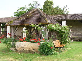
Old well in front of the Chateau
|
||
|
||
| Coordinates: 45°42′38″N 0°08′14″E / 45.7106°N 0.1372°ECoordinates: 45°42′38″N 0°08′14″E / 45.7106°N 0.1372°E | ||
| Country | France | |
| Region | Nouvelle-Aquitaine | |
| Department | Charente | |
| Arrondissement | Angoulême | |
| Canton | Gond-Pontouvre | |
| Intercommunality | Braconne et Charente | |
| Government | ||
| • Mayor (1995–2020) | Jean-Claude Courari | |
| Area1 | 9.64 km2 (3.72 sq mi) | |
| Population (2010)2 | 1,303 | |
| • Density | 140/km2 (350/sq mi) | |
| Time zone | CET (UTC+1) | |
| • Summer (DST) | CEST (UTC+2) | |
| INSEE/Postal code | 16026 /16430 | |
| Elevation | 30–102 m (98–335 ft) (avg. 40 m or 130 ft) |
|
|
1 French Land Register data, which excludes lakes, ponds, glaciers > 1 km² (0.386 sq mi or 247 acres) and river estuaries. 2Population without double counting: residents of multiple communes (e.g., students and military personnel) only counted once. |
||
1 French Land Register data, which excludes lakes, ponds, glaciers > 1 km² (0.386 sq mi or 247 acres) and river estuaries.
Balzac is a French commune in the Charente department in the Nouvelle-Aquitaine region of south-western France.
The inhabitants of the commune are known as Balzatois or Balzatoises.
Balzac is located some 7 km north-west of Angoulême. Access to the commune is by the D737 from Angoulême which passes through the east of the commune and the town continuing north to Montignac-Charente. The D105 branches off the D737 north of the town and goes east to Champniers. The D406 also branches off the D737 and goes west to Vindelle. Apart from the town there are the hamlets of Coursac, La Chapelle, Les Chabots, and Les Courlis in the commune. The commune is mostly farmland with a small forest in the south-west and a significant urban area for the town.
Balzac occupies the interior of a wide bend of the Charente. The bedrock of the large eastern half of the commune, which is the highest in altitude, consists of limestone dating from the Upper Jurassic (Kimmeridgian) period.
The centre of the town, between Labbés, Genin, and Texier, is located on old alluvium from the Quaternary period.
The western part of the commune, between La Chapelle and Chabots, contains other alluvial deposits which form a low terrace. The river bed (floodplain) is itself made up of more recent alluvium (silt, sandy clay, and peat).
The terrain that separates the valley of the Charente from that of the Argence forms a kind of long cliff, very high and steep in its northern part, which is the concave side of the bend in the river near the villages of Coursac and Font-Saint-Martin, which gradually decreases in height to end at the foot of the Chateau of Balzac.
...
Wikipedia


