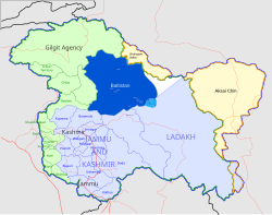
Baltistan
| Baltistan Urdu: بلتستان Balti: སྦལ་ཏི་སྟཱན |
|
|---|---|
 Dark blue: Skardu, Ghanche, Shigar and Kharmang (GB) Light blue: Kargil (J&K); Sky blue: Leh (J&K) |
|
| Coordinates: 35°18′N 75°37′E / 35.300°N 75.617°E | |
| Country | |
| Region |
|
| Districts | |
| Area | |
| • Total | 72,000 km2 (28,000 sq mi) |
| Elevation | 1,500 m (4,900 ft) |
| Population (2002) | |
| • Total | 322,000 |
| Languages | |
| Website |
gilgitbaltistan www |
Baltistan (Urdu: بلتستان, Balti: སྦལ་ཏི་སྟཱན), also known as Baltiyul or Little Tibet (Balti: སྦལ་ཏི་ཡུལ་།), is a mountainous region on the border of Pakistan and India in the Karakoram mountains just south of K2 (the world's second-highest mountain). Its average altitude is over 3,350 metres (10,990 ft).
Baltistan borders Gilgit (རྒྱལ་སྐྱིད) on the west, Xinjiang (China) in the north, Ladakh on the southeast and the Kashmir Valley on the southwest. Until 1947, Baltistan and Ladakh were administered jointly under one wazarat (district) of Jammu and Kashmir. Baltistan retained its identity in this set-up as the Skardu tehsil, with Kargil and Leh being the other two tehsils of the district. After the maharaja of Jammu and Kashmir acceded to India, Gilgit Scouts overthrew the maharaja's governor in Gilgit and (with Azad Kashmir's irregular forces) "liberated" Baltistan. The Gilgit Agency and Baltistan have been governed by Pakistan ever since. The Kashmir Valley and the Kargil and Leh tehsils were retained by India. A small portion of Baltistan, including the village of Turtuk in the Nubra Valley, was incorporated into Ladakh after the Indo-Pakistani War of 1971.
...
Wikipedia
